Aral Sea - formerly closed salt Lake in Central Asia, on the border of Kazakhstan and Uzbekistan. The Aral Sea appeared, according to official history, approximately 20-24 thousand years ago. But is this really so?
I'll start with a comment from chispa1707: in the year 72-76, a friend of my father, a mechanizer-meliorator, who worked in the Ellikalinsky district of Karakalpakstan on the development of virgin lands (it seems for rice cultivation), returned from his shift and said: “We remove the dune with a bulldozer, and there are beds! It turns out that people used to live and there was water! Desert,
At about the same time, the tugboat captain, a distant relative, who was transporting barges from Muynak to Aralsk, noted with surprise that buildings were visible at the bottom - the ruins of houses and duvals. Then the problem of the drying out of the Aral Sea had already emerged and he noted that this meant that in the past the sea was even smaller. Recently, scientists found a mosque on the dried bottom.


It turns out that there are also examples, supported by archaeologists, of the presence of ancient buildings on the former bottom of the Aral Sea:
Aral-Asar

Chronology of the drying up of the Aral Sea
Aral-Asar is a fortification or settlement of the 14th century. Discovered at the bottom of a dry section of the Aral Sea.
To the west of the settlement, remains of rice fields were discovered. The settlement is dated based on the discovered coins of the Golden Horde period.

In 2001, not far from the already dried island of Barsakelmes, a joint archaeological expedition of the Institute of Archeology named after. A. Margulan and Kyzylorda State University. Korkyt-Ata, under the leadership of the candidate of historical sciences T. Mamiev, examined a large, well-preserved mausoleum and other fragments of an ancient highly developed settlement discovered by residents of the Aral village of Karateren. The find was located in the area of depths of 18 - 20 m of the former sea and was sensational.
Then, in 2004, an archaeological expedition of the Korkyt-Ata Kyzylorda State University, led by Professor A. Aidosov, examined the second mausoleum.
The finds were tentatively attributed by scientists to the period of the 12th – 15th centuries.


Nakhodka is located 63 kilometers to the north from the village of Karateren and 370 kilometers from Kyzylorda. The village of Karateren, which not long ago stood on the shores of the Aral Sea, is now 120 kilometers away from it.
According to scientists, the settlement, provisionally named Aral-Asar, occupies an area of 6 hectares. The building structures of the city today are practically indistinguishable; they are blurred and smoothed by the waters of the Aral Sea. But archaeologists have discovered huge quantities of household items: millstones, ceramic vessels and their fragments, fragments of iron and bronze items.


14 millstones and nearby premises for storing flour - khumdans - were found. Apparently, flour milling production was developed.
There was an irrigation canal here, 2 - 2.5 meters wide, passing through the settlement, indicating a developed irrigation system and the fact that the inhabitants brought water here, apparently from the channels of the ancient channels of the Amu Darya or Syr Darya many tens of kilometers away.
Approximate coordinates: 46" 02" north latitude; 60"25" east longitude.
A tree trunk on the dry bottom of the Aral Sea. Consequently, the sea is very young, formed by catastrophic processes, and which disappeared (dried up) not due to human economic activity.
On June 19 – 20, 1990, aerial photography was carried out at a level of the Great Sea of about 38 m abs., that is, after the level had dropped by 15 m. The photographs, taken on a scale of 251 m by 1 cm, unexpectedly revealed hundreds of giant figures shining through the shallow water and lying on dry areas of the seabed. The various figures consisted of single or several parallel lines of unusual shape. The unusualness was in the too regular, not random appearance of many of them. And this appearance suggested their artificial origin. Therefore, the figures were given the name “Traces of unknown activity at the bottom of the Aral Sea” or simply “Aral Traces”. They cover an area of about 500 km2 in the images, but appear to continue beyond the aerial photograph. Before the sea level began to fall, the figures were at depths of 10–15 m and were not visible from the surface of the sea.

For different figures, the lines have a length from 100 - 200 m to 6 - 8 km, and their width, strictly constant within each figure, varies from 2 to 100 m. Some figures can contain up to several dozen parallel lines, reminiscent of a comb stroke up to 1 – 2 km.
Underwater, the lines look like black stripes with narrow light edges, similar to dumps of soil from earthen canals, and when they dry out on the shore, they become whitish and have little contrast. The black color of the lines along some of their length when reaching a drained bank indicates their concave topography, similar to the cross-section of canals, and their filling with water. Based on indirect evidence in photographs and measurements of two figures on the ground, it was established that the lines of the figures are grooves with an initial depth of up to 0.4 - 0.5 m, formed in the sandy-silty soil of the seabed. Light spots on the surface of the water are sun glare. The black lines appearing against their background are convex parts of the furrows in the form of soil dumps rising above the surface of the water.
The age of the furrows, if it is supposed to be estimated in photographs by the degree of swelling of their contours and taking into account the relatively low rate of accumulation of bottom organic sediments, can be approximately determined within a range of up to several hundred years. And the patterns of mutual intersection of furrows (up to four times successively) indicate cases of their sequential formation (conducting) at different times on top of previously created ones.
The official explanation of scientists: this is not the first time the sea has receded. But I have a different version.
On old maps, the Caspian Sea looks different than it does now. Great amount cities were located where there is now desert.
Most likely, this event happened quite recently:

The outline of the Caspian coast has changed. From the east it retreated and moved south. But a huge mass of water remained where the Aral Sea is now drying up. Those. all the buildings found at the bottom of the Aral Sea were cities and villages in the deltas of rivers flowing into the ancient Caspian Sea.
There is this map overlay:
The western part of the border of the ancient Caspian and the present roughly coincides. The Volga delta coincides. But the eastern outline of the ancient Caspian Sea extends far beyond the Aral Sea. It was possibly a single body of water. How settlements of farmers could have been located then is unclear. Perhaps this overlay is incorrect. Not to scale. Or indeed, the level of the Aral Sea fluctuates. And people moved and settled after the receding sea.
Another option is that this is a very ancient map with much more ancient outlines of the Caspian Sea.
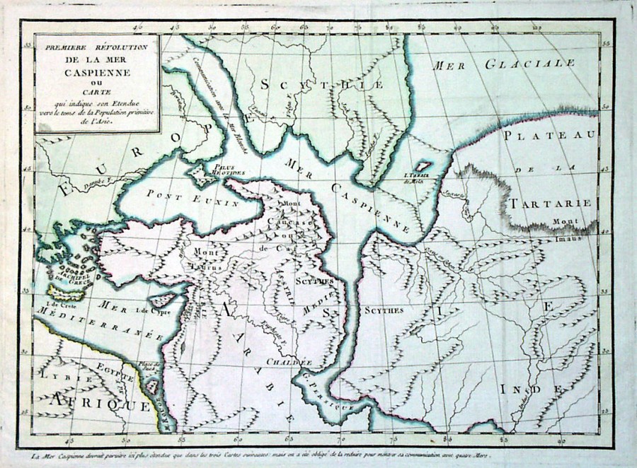
Here the Aral Sea is different. Although the Caspian is already in its modern form.
Clickable. 1723 Joachim Ottens. There is a compass in the center of the map, therefore north on the map is on the left. The Caspian is also different. But it differs both from the real outlines and from the 16th century maps.
It is possible that there were several reasons leading to changes in the outlines of the seas in this region. All to varying degrees of catastrophicity and duration.
Another assumption is that the maps of the 16th century, where the Caspian Sea has an oval shape (stretched from west to east), and not from north to south, as it is now, is an incorrect location of the Caspian Sea on the maps. The compilers redrawn from different sources and did not pay attention to the location of the north:

Here the north is still there, on the left. And this card may have been transferred later as seen.
Then, according to this assumption, it turns out that the Aral Sea previously (recently) did not exist at all. The settlements and finds found at its bottom are the remains of ancient cities, which are depicted in large numbers on these maps. And there really were a lot of cities.
I had several articles about some of the cities and fortresses of this region:
Fortresses of ancient Khorezm
Ruins of the ancient city of Merv
Antediluvian Margiana
Based on this new information about ancient cities on the former bottom of the Aral Sea, I have not yet formed a clear opinion about the shape and geography of the ancient Caspian Sea. Maybe someone will share their thoughts in the comments?
Another fact is that in this previously flourishing region (well, people couldn’t set up so many cities in the desert) something catastrophic happened, not only the deserts and sands speak, but also the level of salinity of the soil and soil:


There are several opinions. Official: this is the bottom of an ancient sea. Another, alternative opinion is that the salts of the flood waters standing in these places were deposited. But there are many lowlands and valleys where such a picture is not observed. Although there should also be water there.
My opinion is that this fact is associated with the release of salty and mineral masses of underground water. And it is in these places in large numbers. I mentioned underground oceans. As can be seen on the maps, there are saline soils and soils even in the north. I think this is due precisely to the powerful output of salty and mineral deep waters to the surface (from underground lakes, seas). It is possible that it was they who fed and maintained the level of the Aral Sea, and not the Syr Darya and Amu Darya rivers.
Archaeological tours at the bottom of the Aral Sea.
"Do not say,
That the path is narrow and difficult,
Who - doesn't go -
It’s even more difficult for that.”
Igor Zheglov.
“At the bottom, strewn with white salt, the outlines of ancient city, the remains of mausoleums, necropolises and settlements are clearly visible. At first, many even jokingly said that the lost Atlantis had been found in Kazakhstan.”
Brief description of the tour route to the Aral Sea:
Aralsk - village Aralkum - Lake Kombash - Amanotkel village - Bugun village - Aklak waterworks - Karateren village - Aral-Asar settlement - Kerderi mausoleum - Kok-Aral dam on the Berg Isthmus - Karateren village - Zhanakurylys village - Lake Katankol - Kazaly village - Orkendeu village - Zhankent settlement - Aiteke Bi village (Kazalinsk).
Route length: 447km
Seasonality: from May 1 to September 10.
Best time to travel: May June.
3 days and 2 nights.
Detailed tour program day by day in the vicinity of the Aral Sea:
1 day. Aralsk - Amanotkel village - Bogen village - Karateren village (184 km.)
The beginning of the excursion around Aralsk, a visit to the railway station, inspection of the station building, inspection of a sailing ship erected on a pedestal and a monument to the victims of repression located on the square near the railway station. Visit to the city museum. Continuation of the city tour: visiting the fishermen's museum, the open-air museum of the ships of the Aral Flotilla, the city square with monuments - the monument to Khan Abulkhair, the monument to Zhibek and Tulegen, the "Kazakhstan" stele, a walk around the square near the akimat and inspection of the monuments - the fisherman and Przewalski's horse, Alley of Heroes. Lunch at the Chinson cafe. Transfer: Aralsk - Aralkum village - lake Kombash - Amanotkel village - Bugen village (154 km). Arrival in the village of Bogen. Visit to the fishermen's village of Bogen, visit to a beautiful local mosque, visit to the surroundings of a local school built in 1954, which is surrounded by sand dunes. Further travel: Bogen village - Aklak waterworks - Karateren village (30 km). Along the way, stop at the Aklak hydroelectric complex on the Syr Darya River, which was built to fill the network of lakes that are located above, in front of the hydroelectric dam and fill the river's floodplain with water, and inspect the hydroelectric complex. Arrival in the village of Karateren, accommodation in a house with villagers, dinner, overnight. Day 2. Karateren settlement - Old Karateren settlement - Aral-Asar settlement - Kerderi mausoleum - Kok-Aral dam - Karateren settlement (101 km).
Breakfast. Transfer: Karateren - Old Karateren settlement - Aral-Asar settlement (66 km). Walk in the vicinity of the settlement, inspection of the settlement. Transfer to the Kerderi mausoleum (2 km), visit to the archaeological excavations of the mausoleum. Lunch on the way. Return to the village of Karateren (68 km). Trip to the Kok-Aral dam (33 km). Inspection of the Kok-Aral dam. The dam separated the Small Aral from the Great Aral Sea .
The length of the dam is 13 kilometers, thanks to the dam, the water level in the Small Aral Sea rose to a level of 42 meters. The dam's sluices regulate the level of the Small Aral Sea and excess water is discharged into the dry Great Aral Sea, the distance to which increases every year. Return to Karateren (30 km). Accommodation in a rural house. Dinner, overnight. Day 3. Village Karateren - village Aiteke Bi (Kazalinsk)-
settlement Zhankent (162 km).
Breakfast. Transfer: Karateren village - Zhanakurylys village - Lake Katankol - Shomashkol village - Kazaly village - Orkendeu village - Zhankent settlement (128 km). Along the way, visit the monument to Asan on the banks of the Syrdarya River. Arrival at the ancient settlement of Zhankent (Yangikent) (XV century). Walk through the ancient settlement of Zhankent. According to medieval written sources, the city of Zhankent (Yangikent) in the lower reaches of the Syr Darya was the residence of the “king of the Guz”. Dinner. Moving to the village. Aiteke Bi (34 km), arrival in the village of Aiteke Bi. Excursion around the village, visit to the memorial museum of Gani Muratbayev (late 19th - early 20th centuries), inspection of monuments to Soviet statesmen, in a small park near the museum, visit to the mausoleum of Karasakala Yerimbet (1850 - 1911). Visit to Ganibay's house (XIX century), the city library building (former Ganibay mosque, 19th century), Nogay mosque (Nuraly mosque, 19th century), building of the regional cultural center named after Rosa Baglanova (former church, 1904). Sightseeing tour around the village, visiting the town square of the village. Dinner. Seeing off to the railway station, departure from Kazalinsk station.
Distances along the route "A lost world on the dry bottom of the Aral Sea».
Finds from excavationsI'll start with a comment from: in the year 72-76, a friend of my father, a mechanizer-meliorator, who worked in the Ellikalinsky district of Karakalpakstan on the development of virgin lands (it seems for rice sowing), returned from his shift and said: “We remove the dune with a bulldozer, and there are beds there!” It turns out that people lived before and there was water! The desert, it turns out, is approaching.”
At about the same time, the tugboat captain, a distant relative, who was transporting barges from Muynak to Aralsk, noted with surprise that buildings were visible at the bottom - the ruins of houses and duvals. Then the problem of the drying out of the Aral Sea had already emerged and he noted that this meant that in the past the sea was even smaller. Recently, scientists found a mosque on the dried bottom.


It turns out that there are also examples, supported by archaeologists, of the presence of ancient buildings on the former bottom of the Aral Sea:
Aral-Asar

Chronology of the drying up of the Aral Sea
Aral-Asar is a fortification or settlement of the 14th century. Discovered at the bottom of a dry section of the Aral Sea.
To the west of the settlement, remains of rice fields were discovered. The settlement is dated based on the discovered coins of the Golden Horde period.

In 2001, not far from the already dried island of Barsakelmes, a joint archaeological expedition of the Institute of Archeology named after. A. Margulan and Kyzylorda State University. Korkyt-Ata, under the leadership of candidate of historical sciences T. Mamiev, examined a large, well-preserved mausoleum and other fragments of an ancient highly developed settlement discovered by residents of the Aral village of Karateren. The find was located in the area of depths of 18 - 20 m of the former sea and was sensational.
Then, in 2004, an archaeological expedition of the Korkyt-Ata Kyzylorda State University, led by Professor A. Aidosov, examined the second mausoleum.
The finds were tentatively attributed by scientists to the period of the 12th – 15th centuries.


Nakhodka is located 63 kilometers to the north from the village of Karateren and 370 kilometers from Kyzylorda. The village of Karateren, which not long ago stood on the shores of the Aral Sea, is now 120 kilometers away from it.
According to scientists, the settlement, provisionally named Aral-Asar, occupies an area of 6 hectares. The building structures of the city today are practically indistinguishable; they are blurred and smoothed by the waters of the Aral Sea. But archaeologists have discovered huge quantities of household items: millstones, ceramic vessels and their fragments, fragments of iron and bronze items.

14 millstones and nearby premises for storing flour - khumdans - were found. Apparently, flour milling production was developed.
There was an irrigation canal here, 2 - 2.5 meters wide, passing through the settlement, indicating a developed irrigation system and the fact that the inhabitants brought water here, apparently from the channels of the ancient channels of the Amu Darya or Syr Darya many tens of kilometers away.
Approximate coordinates: 46′ 02′ north latitude; 60’25′ east longitude.
A tree trunk on the dry bottom of the Aral Sea. Consequently, the sea is very young, formed by catastrophic processes, and which disappeared (dried up) not due to human economic activity.
***
On June 19 – 20, 1990, aerial photography was carried out at a level of the Great Sea of about 38 m abs., that is, after the level had dropped by 15 m. The photographs, taken on a scale of 251 m by 1 cm, unexpectedly revealed hundreds of giant figures shining through the shallow water and lying on dry areas of the seabed. The various figures consisted of single or several parallel lines of unusual shape. The unusualness was in the too regular, not random appearance of many of them. And this appearance suggested their artificial origin. Therefore, the figures were given the name “Traces of unknown activity at the bottom of the Aral Sea” or simply “Aral Traces”. They cover an area of about 500 km2 in the images, but appear to continue beyond the aerial photograph. Before the sea level began to fall, the figures were at depths of 10–15 m and were not visible from the surface of the sea.

For different figures, the lines have a length from 100 - 200 m to 6 - 8 km, and their width, strictly constant within each figure, varies from 2 to 100 m. Some figures can contain up to several dozen parallel lines, reminiscent of a comb stroke up to 1 – 2 km.
Underwater, the lines look like black stripes with narrow light edges, similar to dumps of soil from earthen canals, and when they dry out on the shore, they become whitish and have little contrast. The black color of the lines along some of their length when reaching a drained bank indicates their concave topography, similar to the cross-section of canals, and their filling with water. Based on indirect evidence in photographs and measurements of two figures on the ground, it was established that the lines of the figures are grooves with an initial depth of up to 0.4 - 0.5 m, formed in the sandy-silty soil of the seabed. Light spots on the surface of the water are sun glare. The black lines appearing against their background are convex parts of the furrows in the form of soil dumps rising above the surface of the water.
The age of the furrows, if it is supposed to be estimated in photographs by the degree of swelling of their contours and taking into account the relatively low rate of accumulation of bottom organic sediments, can be approximately determined within a range of up to several hundred years. And the patterns of mutual intersection of furrows (up to four times successively) indicate cases of their sequential formation (conducting) at different times on top of previously created ones.
Sources
http://www.silkadv.com/en/content/aral-asar-gorodishche
***
The official explanation of scientists: this is not the first time the sea has receded. But I have a different version.
On old maps, the Caspian Sea looks different than it does now. A huge number of cities were located in what is now a desert.
Most likely, this event happened quite recently:
The outline of the Caspian coast has changed. From the east it retreated and moved south. But a huge mass of water remained where the Aral Sea is now drying up. Those. all the buildings found at the bottom of the Aral Sea were cities and villages in the deltas of rivers flowing into the ancient Caspian Sea.
There is this map overlay:
The western part of the border of the ancient Caspian and the present roughly coincides. The Volga delta coincides. But the eastern outline of the ancient Caspian Sea extends far beyond the Aral Sea. It was possibly a single body of water. How settlements of farmers could have been located then is unclear. Perhaps this overlay is incorrect. Not to scale. Or indeed, the level of the Aral Sea fluctuates. And people moved and settled after the receding sea.
Another option is that this is a very ancient map with much more ancient outlines of the Caspian Sea.
Sources:
https://gilliotinus.livejournal.com/182063.html
Here the Aral Sea is different. Although the Caspian is already in its modern form.
Clickable. 1723 Joachim Ottens. There is a compass in the center of the map, therefore north on the map is on the left. The Caspian is also different. But it differs both from the real outlines and from the 16th century maps.
It is possible that there were several reasons leading to changes in the outlines of the seas in this region. All to varying degrees of catastrophicity and duration.
Another assumption is that the maps of the 16th century, where the Caspian Sea has an oval shape (stretched from west to east), and not from north to south, as it is now, is an incorrect location of the Caspian Sea on the maps. The compilers redrawn from different sources and did not pay attention to the location of the north:

Here the north is still there, on the left. And this card may have been transferred later as seen.
Then, according to this assumption, it turns out that the Aral Sea previously (recently) did not exist at all. The settlements and finds found at its bottom are the remains of ancient cities, which are depicted in large numbers on these maps. And there really were a lot of cities.
I had several articles about some of the cities and fortresses of this region:
There are several opinions. Official: this is the bottom of an ancient sea. Another, alternative opinion is that the salts of the flood waters standing in these places were deposited. But there are many lowlands and valleys where such a picture is not observed. Although there should also be water there.
My opinion is that this fact is associated with the release of salty and mineral masses of underground water. And it is in these places in large numbers. I mentioned underground oceans. As can be seen on the maps, there are saline soils and soils even in the north. I think this is due precisely to the powerful output of salty and mineral deep waters to the surface (from underground lakes, seas). It is possible that it was they who fed and maintained the level of the Aral Sea, and not the Syr Darya and Amu Darya rivers.
Earrings that were found in a burial at the head of a woman. Dragon biting its tail (Scytho - Sarmatian pictorial tradition).
“At the bottom, strewn with white salt, the outlines of an ancient city are visible, the remains of mausoleums, necropolises and settlements are clearly visible. At first, many even jokingly said that the lost Atlantis had been found in Kazakhstan.”
Plan of the Kerderi mausoleum at the bottom of the Aral Sea. XIV century.
Finds from excavations
Aral Atlantis. The ruins of two cities were found on the dry bottom.

Aral Sea
The remains of an ancient cult temple were discovered on the dry bottom of the Aral Sea. An archaeological expedition that went to the site of the find found that the structure dates back to the 11th-14th centuries and is a copy of the Yasawi mausoleum in Turkestan. Nearby, the graves of dead soldiers were opened, and workshops were found in which tiles and ceramics were made. According to scientists, the temple belonged to the Oghuz people and was located on the territory of the ancient city. As one of the participants in that (2000) expedition, Professor Abylay Aidosov, believes, only a small part of the settlement has been discovered so far, and the main part is still under water, writes Kazakhstanskaya Pravda.
Unfortunately, specialists were unable to continue their exploration of the ancient settlement; the expedition only worked for one season, and then the money ran out. And here is a new, without exaggeration, sensational find. 20 kilometers from the mentioned mausoleum, hunters from the village of Karateren discovered the ruins of another ancient city on the dry seabed. According to them, a group of Kyzylorda scientists left the regional center and spent three days exploring the remains of the ancient settlement. The conclusions they reach can literally cause confusion among historians and archaeologists.
We know about the existence of Atlantis, which unexpectedly left for sea bottom. So far, her search has not brought any results, and many believe that this is only a legend. But, as it turned out, there were cities similar to Atlantis, and one of them was buried by the waves of the Aral Sea. Employees of the Korkyt-ata State University removed a layer of sand from the surface of some destroyed buildings and discovered chaotically located remains of people and domestic animals, indicating that they died at the same time and that there was no one to bury them. The disaster took people by surprise, and no one managed to avoid it. Jugs, iron lamps, coins and other household items were also found at the excavation sites. Everything remained as it was at the time of the death of the city.
According to Professor Abylai Aidosov, the reason for this could be water that unexpectedly surrounded the settlement, and people were unable to escape. As is known, the Aral Sea began to fill again in the 14th century, and it is quite possible that this process proceeded quite quickly.

Ak-Kaya fortress, XIII century
The famous historian Z. N. Buniyatov in one of his works “The State of the Khorezmshahs of the Anushtiginids” describes the campaign of the Khorezmshah’s troops to the Oguz cities of Zhent and Zhankent in the Aral Sea region, carried out in the 12th century. The army walked along the bottom of the dried-up Aral Sea, and the warriors encountered several thriving cities. One of them is Robat-Togan. Perhaps the one found now is the same Robat-Togan, since, according to the description of the chronicler of the Khorezmshah, the city was surrounded by a dam in case of the arrival of water. It was Kyzylorda scientists who discovered traces of the dam. Apparently, the water approached the city during the flood period, but then retreated, and the residents erected this structure to avoid flooding. In case of a natural disaster, they stocked up on food (large vessels were found in which grain was stored). They were buried a meter deep in the ground. However, it seems that the latest flood was so violent and powerful that it covered the city.

Kazakhstani scientists now have a unique opportunity to study the life and way of life of our ancestors. After all, this is not a city abandoned by people and not destroyed to the ground by conquerors, as all other ancient settlements have reached us. Here the waters of the Aral Sea have preserved, including from plunder, everything that ancient people used. But now it is open and not guarded by anyone. And, in our opinion, one should be afraid that lovers of profit will have time to dig in the sand in search of rich burials and gold. The Aral Atlantis is a rare gift for our history, and it would be worth organizing the protection of the ancient settlement while the expedition is organized.
Aral Atlantis. Mausoleum of Kerderi

Women's earrings "Dragon biting its tail" found at the excavations of the Kerderi mausoleum.
“And when he returned, he did not forget about the poor people.
I now understand the needs of disadvantaged people.
Be close to them, since you are a Muslim,
Listen to those who read the Qur'an and the commandments of His Prophet."
Khoja Ahmed Yassawi.
Bringing up the rear of the fort Aral-Asar necropolis, called Kerderi, which was also the border of the settlement. This is a real “valley of the dead”. Before the excavations, it was a 1.6 meter high slumped hill. On the surface of the hill there was a cluster of baked square bricks, measuring 25 x 25 x 5. The mausoleum is oriented according to the corners of the world and has a rectangular shape in plan.
The walls of the mausoleum were made of baked bricks. The southwestern part of the wall has been preserved to a height of six rows of bricks. The entrance to the mausoleum was located in the southwestern part of the structure and was decorated with a portal niche 2 meters wide, the rectangular frame and arch of which were decorated with glazed tiles with floral and geometric patterns and epigraphy.
Fragments of decorative rounded bricks found here suggest that the archivolt of the niche arch rested on three-quarter columns built into the corners of the niche. The mausoleum, located in the central part of the necropolis, is now a sunken hill less than two meters high. But once its walls were lined with baked bricks, and the foundation was a solid structure made of stone slabs.”
Such a massive foundation is atypical for similar structures Central Asia. Apparently, the ancient city planners took into account the characteristics of the soil - unstable and silty. The thickness of the walls is also striking - at the narrowest point it is at least a meter. The entrance to the mausoleum was decorated with a portal lined with glazed tiles that have survived to this day with gold inscriptions in Arabic.
Both men and women with children were buried in the inner gurkhans - halls divided into two parts. In total, researchers found seven Sagan-type burials here, and all of them date back to the end of the 14th century. The central burial, covered with four massive slabs, turned out to be empty. The exception is the burial located in the northwestern axial niche. The grave pit was lined with stone.
The burial was robbed. A tribal leader or other person of high status could probably be buried in it. A pair of gold earrings in the shape of the head of a leopard biting its tail, found in the crypt, raised many questions. Such a subject is completely uncharacteristic for people professing Islam. Of course, those who lived here adhered to this religion.
This find may indicate that in those distant times, the tribal traditions of shamanism and Tengrism, a monotheistic religion in which the supreme god is Tengri, the power that rules the world, were strong in Aral-Asar.” When the excavations of the mausoleum came to an end, scientists found a real treasure, in the southern corner under the floor - a large jug, 40 centimeters high with a side handle.
Inside the vessel were heavily corroded metal products with tools (sickles, scythes, knives) that were used to cultivate the land. In those distant times, they were valued no less than gold. One of the local residents, probably last days existence of the city, he hid all this in a mausoleum, hoping to return here someday. However, water Aral swallowed up the settlement, and the treasure went to archaeologists. The mausoleum dates back to the 14th century.


“Golden Man” from the Issyk-Kul mound

50 km east of Almaty there is a grandiose burial mound complex consisting of 45 earthen pyramids ranging from 4 to 15 meters in height. Most of the burial grounds were plundered by thieves in ancient times, but the side tomb of the Issyk mound remained untouched until 1969, when Kazakh scientists began to study it.
Archaeological excavations lasted about a year. Finally, archaeologist Beken Nurmukhanbetov decided to explore a flat area 10 meters from the central burial. In the tomb, carved from a century-old Tien Shan spruce, the remains of a Saka leader and more than 4,000 gold jewelry were discovered.
The archaeological find went down in history under the name “Golden Man from the Issyk Mound.” The scientific leader of the expedition, Kemal Akishev, was recognized as the discoverer of the tomb, and Beken Nurmukhanbetov, who at that time worked only as a junior researcher, remained in the shadow of the glory of his mentor. Archaeologists made a fatal mistake by not inviting an anthropologist to analyze the remains immediately after their removal. The bones, placed in a separate box, began to quickly deteriorate. It is now impossible to conduct a genetic examination, since the remains themselves have been lost. According to one version, the culprit of the loss is the anthropologist Omurzak Ismagulov, who took the bones for analysis, but lost them while wandering with his laboratory. It is not possible to establish the sex of the buried person, and to this day there are ongoing debates about who the “Golden Man” was - a man or a woman. The head of the excavations, Kemal Akishev, having examined the frontal bones and jaws, claims that a young man between 18 and 20 years old is buried in the tomb. According to Akishev, a large lower jaw with a thin jaw joint is typical for a man, but not for a girl. However, a silk cosmetic bag containing a bronze mirror and red ocher casts doubt on the idea that it was a young man. The sword and dagger found next to the buried person are found in the graves of Saka and Sarmatian women, who, like the Amazons, fought, rode horses and shot with a bow.
Costume of the “Golden Man” and its symbolism
The found armor and funeral attire allowed scientists to recreate the image of the Saka prince-warrior. Lush clothes indicate that the “Golden Man” occupied the highest rung of the social ladder. He was probably a descendant of a Saka leader. The human head is crowned with a “crown” in the form of a high, pointed turban, decorated with gold plates depicting horses, snow leopards, birds and trees with spreading crowns. Placing a golden crown on the prince elevates him to the rank of a sun-like deity and identifies him with the high priest, the warrior god. The leader's neck is decorated with a gold hoop with tips in the form of tiger heads. In the lobe of his left ear, the “Golden Man” wore a gold earring with an ornament of grain and turquoise. The prince is dressed in a thin silk shirt, trimmed with an intricate pattern of gold plates. Over the shirt is worn a caftan, decorated with cast gold plaques depicting animals and birds. The prince's suede trousers are tucked into high boots with glued gold plaques in the shape of a trefoil. On the right, a sword in a sheath covered with red leather is attached to the warrior’s belt, and on the left is an iron dagger in a sheath with gold plates in the form of a galloping elk and a horse. On both sides of the dagger, figures of a wolf, fox, mountain sheep, fallow deer, fox, snake and other animals are carved on gold plates. In addition, in the tomb of dried apricots Issyk, a silver bowl (5th century BC) with 26 writings was discovered, which have not yet been deciphered. The original "Golden Man" is in the state repository, and its copy can be seen in State Museum gold in Astana. There is an opinion that recognizing the “Golden Man” as a symbol of Kazakhstan is incorrect from the point of view of heraldry. As if the pointed headdress of the Saka prince symbolizes the key to the afterlife. However, such an interpretation is incorrect; in fact, the three parts of the pointed crown indicate the sacred model of the Universe: otherworldly underworld, the vain earthly world and the heavenly world, where the supreme deity Tengri reigns. The upper part of the crown is directed to the sky, personifying Kazakhstan, looking towards the future, in which new discoveries in science and technological progress are inevitable.
http://www.putidorogi-nn.ru/aziya/72-zolotoi-chelovek
The remains of an ancient cult temple were discovered on the dry bottom of the Aral Sea. An archaeological expedition that went to the site of the find found that the structure dates back to the 11th-14th centuries and is a copy of the Yasawi mausoleum in Turkestan. Nearby, the graves of dead soldiers were opened, and workshops were found in which tiles and ceramics were made. According to scientists, the temple belonged to the Oghuz people and was located on the territory of the ancient city. As one of the participants in that (2000) expedition, Professor Abylay Aidosov, believes, only a small part of the settlement has been discovered so far, and the main part is still under water, writes Kazakhstanskaya Pravda.
Unfortunately, specialists were unable to continue their exploration of the ancient settlement; the expedition only worked for one season, and then the money ran out. And here is a new, without exaggeration, sensational find. 20 kilometers from the mentioned mausoleum, hunters from the village of Karateren discovered the ruins of another ancient city on the dry seabed. According to them, a group of Kyzylorda scientists left the regional center and spent three days exploring the remains of the ancient settlement. The conclusions they reach can literally cause confusion among historians and archaeologists.
We know about the existence of Atlantis, which unexpectedly sank to the seabed. So far, her search has not brought any results, and many believe that this is only a legend. But, as it turned out, there were cities similar to Atlantis, and one of them was buried by the waves of the Aral Sea. Employees of the Korkyt-ata State University removed a layer of sand from the surface of some destroyed buildings and discovered chaotically located remains of people and domestic animals, indicating that they died at the same time and that there was no one to bury them. The disaster took people by surprise, and no one managed to avoid it. Jugs, iron lamps, coins and other household items were also found at the excavation sites. Everything remained as it was at the time of the death of the city.
According to Professor Abylai Aidosov, the reason for this could be water that unexpectedly surrounded the settlement, and people were unable to escape. As is known, the Aral Sea began to fill again in the 14th century, and it is quite possible that this process proceeded quite quickly.
The famous historian Z. N. Buniyatov in one of his works “The State of the Khorezmshahs of the Anushtiginids” describes the campaign of the Khorezmshah’s troops to the Oguz cities of Zhent and Zhankent in the Aral Sea region, carried out in the 12th century. The army walked along the bottom of the dried-up Aral Sea, and the warriors encountered several thriving cities. One of them is Robat-Togan. Perhaps the one found now is the same Robat-Togan, since, according to the description of the chronicler of the Khorezmshah, the city was surrounded by a dam in case of the arrival of water. It was Kyzylorda scientists who discovered traces of the dam. Apparently, the water approached the city during the flood period, but then retreated, and the residents erected this structure to avoid flooding. In case of a natural disaster, they stocked up on food (large vessels were found in which grain was stored). They were buried a meter deep in the ground. However, it seems that the latest flood was so violent and powerful that it covered the city.
Kazakhstani scientists now have a unique opportunity to study the life and way of life of our ancestors. After all, this is not a city abandoned by people and not destroyed to the ground by conquerors, as all other ancient settlements have reached us. Here the waters of the Aral Sea have preserved, including from plunder, everything that ancient people used. But now it is open and not guarded by anyone. And, in our opinion, one should be afraid that lovers of profit will have time to dig in the sand in search of rich burials and gold. The Aral Atlantis is a rare gift for our history, and it would be worth organizing the protection of the ancient settlement while the expedition is organized.


