For Norwegians, the Lofoten Islands are a remote region lying above the Arctic Circle, which, however, is quite easy to get to. The residents themselves are sure that there is no better place in the world than their islands. Tourists come here from all over the world to see the intricately indented shores and learn about the history of Lofoten, which played an important role in the life of the Vikings.
The Lofoten Islands are an archipelago in the composition, 200 km north of the Arctic Circle.
IN THE EMBRACE OF WARM CURRENTS
The warm climate of the Lofoten Islands, which is not characteristic of such latitudes, was formed due to the proximity to three warm currents of the North Atlantic Ocean at once.
This chain of islands is located in the Norwegian Sea off the northwestern coast of the Scandinavian Peninsula. The islands are separated from the mainland by the Vestfjord bay, forming a 170-kilometer barrier between the Vestfjord and the North Sea. Hence their unofficial name is Lofotweggen, or the Lofoten Wall.
The archipelago consists of seven large and dozens of small islands.
The largest is Eustvogoy, with an area of over half a thousand square kilometers (it contains the highest mountain of the archipelago - Higravstinden), three more - Vestvogoy, Moskenesoy and Flakstadöy - over 100 km 2.
The rocky islands are separated by narrow winding straits and connected to each other by bridges and tunnels. The main local road - the western continuation of the European route EY - stretches across the entire archipelago, ending in the south, on the island of Moskenesoy, in a village with a laconic name from one letter - O, and starting right on the shore of the Gulf of Bothnia at.
The relief of the archipelago is mountainous. Individual peaks rise to a kilometer or more, while they rise almost directly from the sea, presenting an impressive sight.
The hills are covered with ice and are composed mainly of hard rocks: granites, gneisses, syenites, crystalline schists.
The Lofoten Islands are perhaps the oldest rock formations on Earth, dating back about 3 billion years. The current landscape of the islands was formed 10 thousand years ago with the end of the last ice age.
The coasts of all the islands are rocky, they are indented by small fjords. A narrow coastal strip runs along the sea in some places.
The sea off the coast of the Lofoten Islands does not freeze. Unusually mild for such high latitudes, the climate is formed under the influence of warm currents - the Gulf Stream, the North Atlantic and Norwegian. Throughout June and July, the sun does not set below the horizon over the islands, and from September to April, the northern lights shimmer and shimmer over the islands.
The typical landscape of the Lofoten Islands is mountain tundra and heath, there are groves of mountain ash, birch and coniferous trees.
The sea around the islands is full of whales, including sperm whales and killer whales. The rocks have turned into a large bird market, where millions of birds live: puffins, slender-billed guillemots, cormorants, gray herons, bluethroats, fulmars, boobies and swans. At the foot of the rocks there are large seal rookeries. Of the land mammals, the largest are the otter and the elk.
South of Moskenesøy is the Maelström whirlpool, popular in world fiction, resulting from the contact of tidal and ebb waves with the protruding landforms of the seabed, which is extremely complex here, and a heavily indented coastline. The “horrors” of Maelstrom are rather exaggerated: in fact, it is not a huge funnel that pulls more ships to the bottom, but a system of eddies in the strait. Although in ancient times this could happen with a wooden vessel or boat. The Maelström poses a real danger during the maximum tide, with a strong westerly wind, when the direction of the current becomes unpredictable and the ship can break on the rocks of the island of Moskenesoy.
DRIED COD ISLANDS
In the Lofoten Islands, dried fish has been elevated to the rank of a symbol, traditions have developed around it and folklore has developed, it has become the basis of the economy and glorified the islands throughout the world.
The first settlements on the Lofoten Islands appeared about 8 thousand years ago, the Refsvikhula cave was also found with rock paintings that are more than 3 thousand years old.
The name of the islands was originally the old name of the second largest island in the Vestvogöy archipelago. The outlines of the island reminded the ancient Vikings of an animal paw print, and Lofoten is translated as “Lynx Paw”: “lo” is a lynx, “fotr” is a paw, leg. Such names were in use among the Vikings: for example, the name of the neighboring island of Flakstadöy is Warfot, or Wolf's Paw, from "var" - wolf.
The Vikings who settled in Lofoten are believed to have discovered a way to harvest cod. For these brave travelers, dried cod is very convenient: a kilogram of dried fish is equal in nutritional properties to 5 kg of fresh cod, and can be stored for four years.
In 1120, the Norwegian king Eystein I Magnusson, who did a lot for the economic and cultural development of the country at the beginning of the 12th century, built the first rorbu fishing huts in Lofoten and declared himself their owner.
The Middle Ages in Lofoten were marked by skirmishes between supporters of catching cod with a line and one hook and those who set up lines and used nets. In 1644, King Christian IV - the owner of all rorbu - banned traps and nets, but from 1786 fishermen were allowed to catch with all tackle.
IN early XIX V. the kings, in need of money, sold the rorba and the lands around them to wealthy fishermen. Other fishermen lived in constant debt, working it off by catching fish for rorbu owners 24 days a month.
In 1938, the bondage was destroyed: the Norwegian Storting (parliament) passed the Raw Fish Law: from now on, the fishermen themselves set the minimum price for their catch and did not give more cheaply to the owners of rorbu, nets and boats.
Today, in the Lofoten Islands, fishermen themselves decide where to fish with nets, where with lines, observing the main law of fishing: to fish in a strictly designated place. The cod fishing season is January, February and March when the fish come from Barents Sea for spawning.
Life on the islands has always proceeded quite peacefully, wars bypassed them. Only in 1941 did British commandos carry out Operation Claymore on the islands, destroying German oil storage facilities and factories for the production of fish oil and glycerin, which was used by the Germans to produce dynamite.
Nowadays, tourism plays an increasingly important role in the economy of the islands, and rorbu fishing huts are being converted into tourist houses. But terrfisk is cod caught during spawning and withered, which has been sold throughout Europe since the 14th century. - traditionally occupies an important place in the life of the islanders.
They still build stabbur - sheds for drying and storing fish, badstuhe - baths with an open hearth and stuve - residential buildings with a gable roof. Old houses have been preserved, the roofs of which were covered with birch bark and turf, and which were overgrown with small trees.
They are also engaged in sheep breeding on the island, but on a limited scale: there is not much grass here.
The largest settlement by local standards is the port Svolvær on the island of Eustvogoy, for many centuries a fishing village that managed to establish itself in the status of a city in 1996. The town lives off the pier that receives ferries with tourists and serves the same tourists.
The main historical attraction of the Lofoten Islands is in the Lofotr Viking Museum, in the village of Borg, on the island of Vestvogöy. It exhibits the longest Viking dwelling ever found: the chief's house is 83 meters long and 9 meters wide.
ATTRACTIONS
Natural:
■ Trollfjord.
■ Bird markets.
Historical:
■ Stone Age site (Sturbothellaren cave, 5500 years old).
■ Petroglyphs (Refs-vikhula cave, more than 3 thousand years old).
Iconic:
■ Flakstad Church (Flakstadøya, 1780).
■ Gimsey Church (Gimsoy, 1876).
■ Buksnes Church (Vestvogöy, 1905).
Architectural:
■ Road Raftsun Bridge (between the islands of Eustvogöy and Hinnøya, 1998).
Cultural:
■ Viking Museum Lofotr (Borghe, Vestvogoy).
■ Dried Cod Museum (O village, Moskenesoy).
■ Museum of the Norwegian Fishermen's Village (O village, Moskenesøy).
City of Svolvaer (Eustvogöy):
■ Memorial Museum of World War II.
■ House of artistic creativity.
■ Art Gallery Stig Tobiassen.
■ Ski center Kongstind Alpinsenter.
■ Svolver Church (1934).
■ The 150-meter rock of Svolvergate.
CURIOUS FACTS
■ The Maelström whirlpool first appears in Gerard Mercator's atlas in the 16th century. The most famous works in which a “terrible whirlpool” appeared, dragging into the abyss of judgment: the story of Edgar Allan Poe “The Overthrow into the Maelström” (1841), the novel by Jules Verne “20,000 Leagues Under the Sea” (1869), the novel by Louis Jacollio “ Robbers of the seas "(1890).
■ It is generally accepted that mountaineering, which is so popular today in the Lofoten Islands, appeared in 1889: two local fishermen - either on a dare or because there was nothing to do - climbed Mount Vagakallen, 942 m high.
■ The name of the village O is written as A in Norwegian. This letter is also a separate word meaning "river" or "stream". To distinguish the village of O from other settlements in Scandinavia with the same name, it is customary to call it O-i-Lofoten, i.e. O-on-Lofoten Islands.
■ The strangest law adopted by the Norwegian authorities for Lofoten was the decree of 1816, according to which each fishing village was assigned a specific time and place for cod fishing. But since the cod did not know this law, it swam freely from one place to another. As a result, some got a lot of fish, others - nothing. Things almost came to an armed riot of fishermen, and in 1857 the Lofoten Act was canceled, replacing it with the principle "Free waters - free fishing."
■ Lofoten fishermen are considered the most superstitious in all of Scandinavia and try to follow the signs: you can’t start cod fishing on Friday, you can’t whistle on deck, none of the fishermen during fishing should say the word “horse” and call halibut halibut. In the old days, if a black bird landed on the mast, the fishermen hurriedly cut off the nets and headed for the shore.
■ Lofoten fishermen catch Atlantic cod (here they are called Northeast Arctic cod). The fish reaches a length of 2 m, weighs up to 96 kg and can live up to 25 years.
■ Terrfisk dried cod retains all the nutritional properties, while the weight of the dried fish is reduced by three-quarters. The fish is not salted at all and is not subjected to any other processing. Cod is dried for about 2 months. Traditionally dried Lofoten cod is shipped to Spain, Portugal and Italy.
■ An image of a dried cod is featured on the coat of arms of the island and the municipality of Vestvogøy: it depicts two dried fish at once.
GENERAL INFORMATION
Location: Norwegian Sea.
Administrative affiliation: Nur-Norge region, Norway.
Cities: Svolvaer (Eustvo-goy) - 4590 people. (2015).
Language: Norwegian. Ethnic composition: Norwegians.
Religion: Lutheranism (Church of Norway).
Currency: Norwegian krone.
NUMBERS
Archipelago area: 1229.53 km2.
The area of the large islands: Eustvogoy - 526.10 km 2 , Vestvogoy - 411.05 km 2 , Moskenesoy - 185.94 km 2 , Flakstadöy - 109.76 km 2 , Gimsoy - 46.36 km 2 , Veroy - 15.74 km 2 and Röst - 3.60 km 2.
Population: 24,178 (2015).
Population density: 19.6 people / km 2.
Highest point: 1161 m, Higravvstinden.
CLIMATE
Moderate (with features of the subarctic) oceanic humid with relatively warm winters and cool summers.
Average January temperature: 0°С.
Average July temperature: +12°С.
Average annual rainfall: up to 800 mm.
Average annual relative humidity: 75%.
ECONOMY
Agriculture: animal husbandry (sheep breeding).
Sea fishing (herring, cod). Fish farming.
Service sector: tourism, transport, trade.
The Lofoten Islands must be visited at least once in a lifetime. Their territory is located beyond the Arctic Circle, 1,800 km from St. Petersburg, directly to the north - approximately at the latitude of Murmansk. The road to them resembles a fairy tale and passes through green Finland, gloomy Sweden, and after the Keruna pass passes into bright Norway. Near the city of Narvik, a bridge was built on the Lofoten archipelago.
Experienced guides of the Adventure Time tourist club told about what to see in the Lofoten Islands, how to get there, what to eat, where to stock up, where to live and many other useful things.

Denis Alimov
Senior guide of the tourist club "Adventure Time", in active tourism since 2004. Program developer for Norway, Iceland, Nepal, Sri Lanka, Thailand.

Dmitry Klimenko
Guide-leader, has been working in the Adventure Time club since 2007. Travel leader in Norway, Finland, Nepal, Thailand, Sri Lanka, Vietnam.

Stas Piirainen
Guide-leader, has been working in the Adventure Time club since 2011. Travel leader for Norway, Iceland, Georgia, Nepal, Sri Lanka and Thailand.
The material is based on the lecture “Lofoten Islands. How to get into a fairy tale with friends”, held in the Sport-Marathon store in autumn 2016. You can watch the video or read the blog. Unfortunately, there was a sound glitch in the video broadcast in the first minutes, so the material on the blog turned out to be more complete.
Lofoten Islands. How to get into a fairy tale with friends.
What to see in Lofoten?
First of all, mountains with snow-white tops and a non-freezing transparent ocean with many fish. But not only. Lofoten is also snow-white beaches, steep banks, forests, lush green meadows with many sheep. The islands are practically deserted.

If you look at the statistics, quite a lot of people come here during the season, the fact is that the season lasts 1.5-2 months. But even at this time there is no pandemonium. The islands have become famous largely for their panoramic views.

A large number of routes lead to viewpoints - and they are all summarized in a single guide. However, it is not enough to see the islands only from land, they need to be seen from the water. You can't think of anything better than a kayak for this - it allows you to go between small islands and see the peaks you were on yesterday. And feel the power of the ocean. Without a kayak, you will not be able to see, for example, the Laukvika lagoon. This is a deserted area, collected from many small islands with white sand beaches. It is very calm in the lagoon itself, but as soon as you go beyond its borders, you immediately understand that you are in the ocean. The surface of the water can smoothly rise by 3-4 meters - this is the so-called ocean swell. It is good to get to the Trollfjord by kayak, a narrow sea bay with sheer cliffs. Its depth is more than 100 meters, they go there cruise ships. We also go there on kayaks, fish - and this is one of the most vivid impressions in Lofoten.

Leknes and Svolvaer are two relatively large towns in the Lofoten. Each of them has its own peculiarity. Svolvaer is a seaside town with a large port where ferries come from the mainland, while Leknes is the administrative center, it is inland and has no access to the sea. There are many more villages in Lofoten, colorful in their own way. For example, the famous small town Å is the last settlement in the Lofoten archipelago.
Mountain trekking in Lofoten
The weather on the islands is changeable, and in order to build your hiking trip correctly, this moment must be taken into account. Roads lead to the starting points of all routes: somewhere unpaved, somewhere asphalt. This allows you to move very quickly. It is very important to have blocks in stock that allow you to change routes - say, the one in the north, the one in the south, depending on the direction of the wind. This way you can change directions, save time and make your trip more productive. Almost all routes, even the longest ones, are one-day. They require an early exit, at 6-7 in the morning, but at the same time the whole journey can be completed at 17-18 hours. There are also two-day routes, with an overnight stay. However, it is simply impossible to leave on the islands for more than two days.
There are also very small routes that can be completed in 4-5 hours. But they are very cool - having climbed one peak, I want to climb the other seventy. Information on routes can be found on specialized sites.

During trekking, the long daylight hours are very relaxing - in June-July the sun shines for 24 hours, minus bad weather. By the way, about bad weather. On the route, you need to pay attention to where you can take shelter in case of rain, so as not to walk on a wet slippery path, which becomes quite dangerous. Changeable weather means careful attention to clothing. It is necessary, of course, to have a backpack with waterproof protection - it must have a change of dry clothes. Jackets and pants are made of Gortex. You also need to have good trekking poles and boots, because the mountains are quite steep and rocky. Take crocs with you on a trip (slippers that dry very quickly and weigh nothing - it’s better to buy expensive ones, they last longer). It is good to have rubber boots in the car, not very high, of medium length - with them the feet will definitely always be dry.
Lofoten food display
If you are traveling to the Lofoten Islands by car, then it is better to bring most of the products from Russia. However, keep in mind that vegetables, fruits, meat and dairy products cannot be imported into the Schengen area - they can be seized at the border. Keep this in mind when planning your layout. If you plan to pass through Sweden, it makes sense to buy something there. We recommend stopping by ICA supermarkets and stocking up on inexpensive potatoes, cabbage, onions, cheese, sausages, marinades (beets, cucumbers) and olive oil (take a five-liter bottle right away)
Why buy it in Sweden? Because everything is very expensive in Norway. For example, in a campsite, eating scrambled eggs for breakfast will cost 1,000 rubles.
Where to buy groceries in Norway? We try to visit chain stores - Rema1000, KIWI or Coop. Lofoten is a fish place, but you can’t buy fresh fish in stores, it’s mostly frozen and costs a lot of money. There are also relatively cheap products - for example, shrimp for 29 crowns, pasta for 7 crowns, and so on. It makes sense to buy butter, spreads, jams, jams, herring in buckets, yoghurts, milk and bread brand Kneip. By the way, a little trick - go for bread in the morning, because it is at this time that the so-called social products appear in stores, which come in small quantities and are not very expensive.
Lofoten cod
Fishing in Lofoten has always been associated with a very expensive activity, but it turned out that cod can easily be caught from a kayak. My first experience was terrible - in two hours I caught about 35 kg of cod. It wasn't fishing, it was a long, constant retrieval and storage of fish. Despite the fact that I did not take fish less than 2.5 kg. We then suffered a lot, cleaning the fish. And only then did they find out that they only need to take fillets. This year we got 15-16 kg of it - we ate for about four days.

Going to Lofoten and not catching cod is stupid. But you need to prepare for fishing: buy a spinning rod, a reel, a cord (not a fishing line!), a lure. No permissions required. This is if we are talking about sea fishing. For river and lake there are a lot of restrictions, up to the disinfection of spinning rods. What are the nuances when catching cod? It is not forbidden to catch from bridges, but it is undesirable, because passing small vessels can catch on a lure and injure a person. In Norway, this is monitored and they can even call the police if they see someone fishing from the bridge. Keep in mind, if you have a watercraft, then you must have a life jacket - its absence will cause concern for local residents. You need to catch at a depth of 30 meters and at high tide - cod at this time comes and begins to feed (there are sites where the tide time is indicated, do not be too lazy to look there). It is best to fish from hills - from shallows or islands, where the bottom relief bends and where there may be crustaceans or small fish that cod feed on.

I recommend fishing with a strong spinning rod - and the simpler it is, the better. And preferably with a marine coil. Be sure to use a cord - its cod does not bite, although I had situations when even it broke off. But the fish will bite the line without any questions at all. You need to catch on a large lure - the more baubles, the more likely it is that the fish will bite. The spinner should weigh at least 100 grams, and no bait is needed. Keep in mind that it must be equipped with a carabiner, in case it breaks when eating. There must be a cord no shorter than 100 meters so that it can reach the hundred-meter bottom. Caught fish can not be cut, not gutted, just cut the fillet from the sides with a special knife. If the meat is not fried or frozen during the day, it will begin to decompose. Therefore, the catch must be prepared immediately - so the cod will be stored for much longer. What to do with fish waste after you cut the fillet? You need to collect them, put them in a bunch on the shore and continue to watch the battle between the seagulls. Within an hour, there will be no trace of the fish. Unfortunately, caught cod (fresh or frozen) cannot be brought into Russia. The first question at the border, when they find out that you are coming from Norway: “Are you bringing cod?”. But fried, dried and generally processed fish can be imported. The same goes for mushrooms, by the way.
In addition to cod, there are mussels in the Lofoten Islands. But it's not so easy with them. Firstly, they are on the rocks and you need to collect them at low tide. You need to take not everything in a row, but those that are at least half the size of a palm. (photo of mussels in a cauldron). You need to collect them with gloves (the most ordinary construction ones will do), because it is very easy to injure your hands. It’s also good to have a knife, like a construction knife, to separate mussels from stones. Where to look for mussels? Pay attention to the stones that abruptly go into the sea - whole colonies of these mollusks are visible on them. And the best way to cook them is to boil them first so that they open up (they should boil for literally 5 minutes). Then drain the water and fry the mussel meat in hot oil.
To Lofoten - by car
How to get to the Lofoten Islands? There are two ways. The first is by car. (map photo) Since we ourselves are from St. Petersburg, we are considering the road from there. The direct route is through Finland. There are several border crossings, the best option is in the city of Svetlogorsk. There are usually not many people there. The total distance to Svolvær (the administrative capital of the islands) is 1,600 km. It is logical to split the road in half and make a stop approximately in the middle in the town of Kemi (St. Petersburg - Svetlogorsk - Kemi, 826 km - 1 day), you can, of course, plan more stops. The very length of the Lofoten Islands on the road is about 190 km, that is, to see the islands, you need to wind about another 400 km. So you can cover all the most important places. In total, the entire trip to Lofoten will take approximately 11 days (including the road and being there), and the total mileage will be 3,570 km. You will need to spend about 500 euros on gasoline for a passenger car.
Lofoten and North Cape - by car
If you are driving your own transport and climbing so high into the north of Scandinavia, it is logical to get to the iconic point at the same time - the northern tip of continental Europe, the North Cape. We recommend splitting this trip into two, stopping somewhere in the Sibotna area (places where there are very beautiful mountains, similar to the Alps, with many trekking routes) or Alta (there is a rock art museum). These are additional 912 km: Svolvaer - Skibotn - 393 km, Skibotn - North Cape - 518 km. (photo map of the return route). It makes sense to lay the return route through the territory of Russia, because this way you will save on gasoline - in Russia it is still cheaper than in Scandinavia. The road passes along the new Cola track, which is very well done. However, you can also travel around Finland, it will be 200 or 300 kilometers less, but you will be more expensive. The route passes through Karelia, which is also very Beautiful places. In total, the way back, if you are coming from the North Cape, will be more than 2,000 km (Nord Cape - Kandalaksha - 913 km, Kandalaksha - St. Petersburg - 1,110 km). The route with a visit to the North Cape will take a total of 14-15 days and will be 4,900 km (another 700 km to Moscow). It's quite stressful for those who haven't traveled long distances, but the upside is that you can load a lot of food and various equipment into the car.
To Lofoten - by plane
Airplane is the second way to get to the Lofoten Islands. Unlike the car, the way there will be one day (by car - two). And if you buy the right tickets, then 12 hours. Aeroflot flies from Moscow (morning flights), from St. Petersburg - the Rusline company (also a morning flight). From the same airport in Oslo, on a Norwegian domestic flight, you need to fly to the city of Evenes, from where it is a 2-hour drive to the islands. Rent a car or use public transport. But it is not always possible to pick up tickets so as to fly within one day - you need to try very hard to find them.
Where to live in Lofoten
Tent
The easiest option is a tent. This type of housing has pros and cons, of course. The advantages include the inexpensive cost of camping (and spending the night in a wild place is completely free) and solitude. The disadvantages are the limited amount of space and the lack of electricity and general amenities. It is not recommended to camp in a large camp outside the campsite in Lofoten. If one person or a group of people put up a tent on the beach for one night, this will not be a strong violation of the law. Lots of people do it, no problem. But if it's already two nights, then with a probability of 90% the police will arrive the next day. Norwegians treat nature as their own home, in their eyes, this situation looks like you came, say, to a summer cottage, set up a tent there and go to the toilet under the bushes. And the inhabitants of Norway are very strict about toilets and, as a rule, dig holes for these things. But on beaches and prominent places, digging anything for such a purpose is prohibited.
Norway suits tourists of any profile. Here's something for the fans active rest- hiking, rafting, fishing, horseback riding. At the same time, there are places where you can retire in the bosom of idyllic nature. These include, for example, the Lofoten Islands.
Lofoten Islands
Giants and dwarfs
Norway has 50,000 islands at its disposal! They are scattered along the entire coast of the Scandinavian Peninsula. The Lofoten archipelago is located in the northwest of the country. It is washed by the waters of the Norwegian Sea. The archipelago includes many small rocks, lifeless tiny land areas and seven large islands.
The largest of them is called Eustvogöy. Its rocky peaks, cut like a knife by narrow fjords, are quite suitable for filming fantasy films. The highest peak of the island is Higravvstinden (1146 m). It has long been chosen by climbers.
Vestvogoy is the second largest island in the archipelago. Thanks to the cliffs - steep coastal cliffs - it is considered the most beautiful in Norway. Moskenesoy is third in size. It contained only one village. Then, as they decrease, the islands of Flakstadøya, Yimsøya, Værøy and Röst follow.
Breath of the Gulf Stream
The archipelago is located beyond the Arctic Circle. If you mentally walk along the parallel to Russian Siberia, it turns out that Lofoten is located north of the Pole of Cold in the Yakut Oymyakon. It would seem that severe frosts should reign on the islands. Nothing like this! Even in winter, the air temperature does not drop below zero. Saves the warm breath of the Gulf Stream! True, even in the height of summer it can be cool here.

Lofoten joys
Dive into the maelstrom
The word "maelström" is often used as a symbol of danger. And this is no accident. This is the name of the terrible whirlpool between the islands of Ferø and Moskenesøy. It was mentioned with horror by the chroniclers of the Middle Ages. In their works, the Lofoten funnel was described by Edgar Allan Poe and Jules Verne. Externally, the whirlpool looks like turbulence on the water. Watch him from a respectful distance.
The cult place of the island of Eustvogoy is the "Devil's Gate" - a giant boulder stuck between the rocks. It is located near the town of Svolvaer. Nearby rise the "Dragon's Teeth" - two pointed rocks that rock climbers adore. In the fishing villages, you can see how cod is dried - an exotic sight for the townspeople. There is a beautiful church in the commune of Vaughan.
The main local history museum of the archipelago is located in Sturvogan. Its iconic exhibit is the oldest fishing hut in Lofoten. She even has her own name - Skrovabya. It was built in 1797. And in the town of Borg, it is worth visiting the Viking Museum.
Among the island attractions, it is also worth noting the Oceanarium and the Lofoten History Museum in Kabelvag. The Fishing Industry Museum operates in Melbu, and the Ice Museum operates in Svolvaer. Fans of outdoor activities will certainly be interested in kayaking and sea eagle safaris. Those who wish can ride bicycles around the archipelago.

Relax point
There is truth in the legs
A popular hiking route in Lofoten involves visiting the extreme southern point of the archipelago in a village with the sonorous name "O". Along the way, you can climb to the best panoramic point, which is the top of Mount Mannen.
The program includes visits to the typical fishing village of Reine and the Lofoten capital Svolvaer. The list also includes the most popular beaches of the archipelago. You probably won’t want to swim here, but you can admire the magnificent landscapes from the heart.

Polar Lights
Our tourist club offers the following hiking programs in the Lofoten Islands:
- Tour of the Lofoten Islands and the Norwegian Sea on sea kayaks + trekking in the mountains
- Northern pearls of Norway - Lofoten and Vesterålen. Kayaking, trekking, self-guided
polar miracle
There are such enchanting natural phenomena that they remain in memory forever. These include the Northern Lights. The peculiarity of the phenomenon is that it is observed only at high latitudes. Since the Lofoten Islands are located here, there is a chance to see this miracle with your own eyes. True, you have to be lucky!
In spring and autumn, this natural fireworks display is more frequent than in winter and summer. You will also need a flash of solar activity and cloudless weather. If you arrive during the specified period and stay here for a week or two, the probability of seeing a rare sight increases significantly.

Features of Norwegian fishing
Skrei hunting
The fishing season in Lofoten is called "lofotfiske". For the night, fishermen can stay in rorbu - old fishing huts. The best time for fishing is the period from May to September. In summer, at the height of the Polar day, you can fish at any time of the day. But if you want to catch a real Norwegian “skrei” (cod), you have to go here from January to March. Why? In the summer, the local cod goes to the Barents Sea.
Evenes: the meeting place cannot be changed
The fastest way to get to the Lofoten Islands is by plane. You should look for flights to the Norwegian airport Evenes. From the city of Kandalaksha, Murmansk region, bus transfers are organized for tourists. Evenes can also be reached by private car. All routes in the archipelago start from this town.
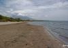
You can see that the Lofoten Islands are an archipelago in the northwest of the country in the Norwegian Sea. Its rocky islands are separated by small straits, and the archipelago is separated from the main territory of the country by the Vestfjord Strait. The Lofoten Islands are a piece of unspoiled nature with untouched landscapes, beautiful bays, white sands and crystal clear waters.
general informationThe archipelago consists of many small islands and 7 large ones (Eustvogoy, Vestvogoy, Moskenesoy, Röst, Yimsoy, Yalakstadöya, Veroy). The total area of Lofoten is 1227 sq. km. The capital of the Lofoten Islands is the city of Svolvaer on the island of Eustvogoy - the administrative, commercial, fishing center.

Small villages have been built on the Lofoten Islands, in which about 25 thousand people live. The main occupation of the islanders is sheep breeding and fishing. Catch mainly cod. Fishing bases in the Lofoten Islands in Norway are located everywhere.


Climatic conditions
The climate of the Lofoten Islands belongs to the temperate maritime, which is characterized by small annual and monthly temperature amplitudes, heavy rainfall, and strong winds. The maximum positive temperatures were recorded in July, the thermometers reach +25°С. In winter, the Lofoten Islands are cooler, while thermometers record up to + 5 ° С.
 Attractions
The archipelago keeps a lot of amazing things. The main attractions of the Lofoten Islands are as follows:
On the island of Eustvogoy


Vestvogoy Island


Flakstadøy island


Moskenesoy island

 Entertainment
 After sightseeing, you can have some fun. Whale safari is a popular pastime among tourists. The timing of the appearance of whales near the Lofoten Islands is from mid-autumn to mid-winter. In addition, if you wish, you can conquer one of the mountain peaks on foot or by bike, go kayaking and sea - in the Lofoten Islands.

A pleasant reminder of a trip to the Lofoten Islands in Norway will be picturesque photos of the most interesting places archipelago.
AccommodationThe choice of housing in the archipelago is huge. Each island has one or more small ones, you can rent a house or spend the night in a van. The following establishments are popular:
- in demand among foreigners Anker Brygge on the island of Svolvaer. The hotel offers cozy rooms, excellent service, affordable prices;
- An excellent hotel on the island of Heimea is the Henningsvær Bryggehotel. Guests can expect comfortable rooms, excellent cuisine, helpful staff;
- 4-star hotel Lofoten Suitehotel will delight you with affordable prices and value for money.
 Restaurants
 The Lofoten Islands have a large selection of catering places. You can find a cozy cafe and an expensive restaurant. Tourists like to spend time at Krambua Restaurant, Borsen Spiseri, Anitas Sjømat, where you can taste great cod and lamb dishes.

How to get there?
Future tourists are often interested in how to get to the Lofoten Islands. There are several ways to do this:
- By plane. Every day, flights depart from the capital to Evenes Airport, which will take you to your destination in 1.5 hours.
- On a ferryboat. Small ferries depart from the harbor every day. Travel time is half an hour.
- Traveling to the Lofoten Islands by car is possible on the road leading from Narvik. The city and the archipelago are connected by a bridge. Thanks to this, walks and excursions around the Lofoten Islands can be organized independently.
At 19-30 MS "Midnatsol" leaves Bodø and continues its journey to the North. Tonight we have to overcome one of the most unusual sections of the route: first, a 102-kilometer open sea crossing to the Lofoten Islands; then we will get acquainted with one of the most amazing Norwegian archipelagos, make an interesting transition from Stamsund along the islands to the neighboring town of Svolver, after which we will head through the narrow straits to the neighboring archipelago - Vesterålen, where we will stop at midnight in the town of Stokmarknes, on the embankment of which the Hurtigruten museum and the historic Finnmarken ferry towers majestically on a pedestal. However, first things first.
Leaving Bodø, we head to the open sea (of course, if we are to be thoroughly meticulous, we can’t call it completely open, but compared to other sections of the coastal line, this concept is quite suitable here) and heading for the barely visible on the horizon archipelago of the Lofoten Islands. The passage to Lofoten takes about four hours - to the left of us stretches the open space of the Norwegian Sea (however, still protected from the harsh Arctic Ocean by the distant ridge of Lofoten), and in the distance to the right in the direction of travel, the entrance to the narrow part of the Vestfjorden Bay is more likely to be guessed than observed, at the farthest tip of which (the daughter fjord Ofotfjorden) is Narvik - a fairly large city and port on the coast of Norway, to which, by the way, part of the Hurtigruten ships are assigned.
7. We are heading for the Lofoten Islands, the ridge of rocks of which is visible straight ahead on the horizon ... Lofoten is 100 kilometers from here:
The Lofoten Islands, together with the Vesterålen archipelago, located to the north, are an amazing and fabulous world. The largest of the islands are Moskenesoy, Vestvagoya and Austvagoya. At the southernmost tip of the Lofoten archipelago, which protrudes far into the Norwegian Sea, there is a village with the short name O (Å), and even further into the sea, the islands-rocks of Veroya and Rösta, separated from the rest of the archipelago by the Moskenstraum Strait, protrude. Here, in the Moskenstraum Strait, there is one of the most powerful and famous whirlpools in the world - the Maelström (or, which is also often used, the Maelstrom). This whirlpool has been known for several centuries and appears in the denouement of Jules Verne's famous novel "20 Thousand Leagues Under the Sea" - when the submarine "Nautilus" spun in this deadly whirlpool, Professor Pierre Aronnax, his faithful servant Conseil and the whaler Ned Land made a daring attempt to escape from the Nautilus and managed to escape from the captivity of Captain Nemo. In general, I really love Jules Verne, and this book is one of my favorites: whoever has not read it, I highly recommend it! But in fact, the Maelström is not as scary as the famous French writer describes it. At this point, the Norwegian Sea joins the Vestfjord through the narrow mouth of the Moskenstraum Strait, only 4 kilometers wide and 60 meters deep. Linked by a strait, the Norwegian Sea and its Vestfjord Bay are much deeper. A whirlpool in the strait arises as a result of the interaction of tidal and ebb waves with a complex bottom topography and a heavily indented coastline and is a complex system of eddies - in the center of the whirlpool, even in calm weather, water “boils” with a roar.
But back to the islands. The famous Lofoten Wall is formed by countless islands that seem to storm the sky, rising from the sea. Sheer cliffs are replaced by gently sloping shores, where you look - fantastic, grandiose landscapes. Along the verdant land oases stretches a chain of picturesque fishing villages on stilts. Well-defended bays contrast with impregnable sheer cliffs whipped by storms. Through the cold transparent emerald water, the seabed is visible to a depth of up to ten meters. Despite the fact that the archipelago is located beyond the Arctic Circle and much north of Verkhoyansk and Oymyakon - the cold poles of the Northern Hemisphere, due to the influence of the Gulf Stream on the islands of the archipelago, the temperature of even the coldest month of winter is almost always above zero. At the same time, the weather here changes instantly - the Lofoten Wall, which forms a barrier between the open sea and the mainland, keeps rain clouds, so it often rains on the islands. The inhabitants of the Lofoten Islands are distinguished by a cheerful and calm disposition. These are hard workers living far from the mainland and sacredly honoring mutual assistance and mutual assistance. When schools of Arctic cod come here from January to April from the Barents Sea, fishermen from all over Norway come to Lofoten.
10. Meanwhile, we have overcome the wide expanses of the Vestfjord Bay, and four hours ago, the rocks of the Lofoten Islands, visible only on the horizon, now rise in front of us in sheer cliffs. MS "Midnatsol" enters a secluded bay and at exactly 19-00 moored to the pier of Stamsund - a small fishing village with a population of about a thousand people, located in the heart of the Lofoten archipelago.
12. For a short half-hour parking, you can manage to get around the quarters of the village closest to the pier, and also climb the rocks, from where a very beautiful view opens.
Stamsund, like Lofoten in general, is a deep Norwegian province, where life goes on measuredly and leisurely, and people are much simpler and more direct than in big cities. Although with all this, we need to make an adjustment for the fact that we are in Norway - in Stamsund there is everything for a normal comfortable life: excellent housing equipped with the latest technology, good roads, through 3 bridges, 7 tunnels (the two longest of them - 6370 and 3337 meters respectively) and one ferry crossing connecting Lofoten with the mainland; there is a modern connection, communications, supermarkets, a hotel and even a restaurant with a pub. Province, yes ... :))
And we, having walked around a small cozy town, hidden among the rocks by the sea, continue our journey and head for Svolver - a town also located in the Lofoten archipelago. The harsh beauty of Lofoten:
It was here, in Lofoten, that one of the most long-awaited divergences on our route took place - the Richard Wise ferry, named after the legendary founder of the Hurtigruten line, was heading towards us. Ferry Richard With was built in 1993 in Germany. Passenger capacity of the vessel - 691 people; sleeping places - 490; places for cars - 45; speed - 15 knots (approximately 28 km / h); length - 121.8 m; width - 19.2 m; draft - 4.9 m; gross tonnage - 11,205 tons.
28. Shortly after the divergence, the ferry makes the next stop - from 21-00 to 22-00 MS "Midnatsol" stands in the town of Svolver (Svolver) - the capital of the municipality of Vagan, the largest settlement of the Lofoten archipelago.