Lake Maashey
natural attractioninformation updated: 07/10/2010
Information about the object Republic of Altai, Kosh-Agachsky district


Lake Maashey
Lake Maashey is located at an altitude of 1984 m in the valley of the Maashey River on the North Chuysky Range.
In the upper reaches of the valley there is a modern glacier, 6 km from which there are several moraine ridges, witnesses of the ancient lower position of the glacier. From the niches located on the sides of the main valley, powerful ridges-tongues emerge. One of these ridges, reaching a height of 30-40 m and about 700 m wide, practically blocks the entire valley. This powerful tongue of glacial-colluvial material consists of several generations and does not reach the right, steep rocky slope of the valley, only 40-50 m.
A collapse came down from this right slope, which formed a barrier to the flow of glacial waters, which led to the creation of Lake Maashey. Apparently, Lake Maashey appeared relatively recently (about 100 years ago). This can be judged by the flooded forest and the dry larch trunks still rising above the water. Some larches above the water still have branches.
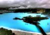
The lake is small, has a length of about 1.5 km, a width of 400 m. The water in it is muddy, of a gray hue. The depth of the lake does not exceed 3.5 m, but it gradually becomes shallower, being filled with material brought by the river from the glacier and from the steep and high slopes of the valley. Often in winter and early spring, the basin of the lake is drained and then the bottom of the lake is exposed. In summer, the level of the lake depends on the melting of glaciers. In years of strong melting, it rises, with a decrease in runoff, on the contrary, it becomes smaller.
Excess water is filtered through the dam. The main outflows of the lake's waters are observed from the opposite side of the dam, and only one (not the most powerful) outflow is noted in the lower part of a narrow "valley" depression along the right slope of the valley. From these exits the Maashey (Mazhoy) river begins - one of the large tributaries of the Chuya river.
From the shores of the lake, the highest peaks of the North Chuya Range are clearly visible: Karagem Peak (3750 m) and Maashey Peak (4173 m).
Lake Maashey is the best place for lovers of mountain and hiking tourism, it presents the possibility of radial exits to the foot of the glaciers, visiting mountain lakes(including Shavlinsky) and waterfalls. A visit to the valley of the Maashey River, a lake and a glacier is carried out as part of combined tours (auto + trekking).
This is how M.V. describes this lake. Tronov, a well-known glaciologist: “This lake is wonderfully beautiful, in the turquoise water of which the majestic panorama of the sources of Masha is reflected. Along the edges, it is framed by the bristles of the trunks of dead trees, sticking out of the water, sometimes at a considerable distance from the shore. Maasheyskoye Lake is located on the Maashey (Mazhoy) River and has a length of 1.5 km, a width of up to 400 m. It was formed about 100 years ago as a result of a landslide that blocked the riverbed. Bypassing the lake along the western shore and following further along the channel of the Maashey, you can reach the Bolshoy Maashey glacier, from under which the river flows.
As is known from various sources, in the upper reaches of the valley there is a modern glacier, 6 km from which there are several moraine ridges, witnesses of the ancient lower position of the glacier. From the niches located on the sides of the main valley, powerful ridges-tongues emerge. One of these ridges, reaching a height of 30-40 m and about 700 m wide, practically blocks the entire valley. This powerful tongue of glacial-colluvial material consists of several generations and does not reach the right, steep rocky slope of the valley, only 40-50 m. A landslide descended from this right slope, which formed a barrier to the flow of glacial waters, which led to the creation of Lake Maashey . Apparently, Lake Maashey appeared relatively recently. This can be judged by the flooded forest and the dry larch trunks still rising above the water. Some larches above the water still have branches.
The depth of the lake does not exceed 3.5 m, but it gradually becomes shallower, being filled with material brought by the river from the glacier and from the steep and high slopes of the valley. Often in winter and early spring, the basin of the lake is drained and then the bottom of the lake is exposed. In summer, the level of the lake depends on the melting of glaciers. In years of strong melting, it rises, with a decrease in runoff, on the contrary, it becomes smaller. Excess water is filtered through the dam. The main water outlets of the lake are observed on the opposite side of the dam (from these outlets the Maashey (Mazhoy) River begins - one of the large tributaries of the Chuya River) and only one (not the most powerful) outlet is noted in the lower part of a narrow "valley" depression along the right slope of the valley . From the shores of the lake, the highest peaks of the North Chuya Range are clearly visible: Karagem Peak (3750 m) and Maashey Peak (4173 m). From Lake Maashey, you can hike to the glacier of the same name.
Due to heavy rains and mudflows, the transverse moraine wall of Maashey Lake was washed out, as a result of which the lake “leaked” from its bed. According to tourists, it happened on July 17, 2012.
This event was preceded by heavy rains that have been falling in the mountains of the North Chuya Range since July 5. Precipitation led to a sharp rise in water levels, including in the Ak-Tru and Chuya rivers. Streams of water demolished the Oroi bridge on the Chuya, a powerful mudflow came down in the area of the Akt-Tru glacier. On July 17, the moraine rampart, which “propped up” Lake Maashey, was washed out, and water flowed out of it.
Tourists who visited the lake area after that say that now a river flows along the bottom of the bed. Is it possible to “restore” the lake, the interlocutors of Novosti Gorny Altai» difficult to say.
Lake Maashey appeared about a hundred years ago, when a powerful landslide blocked the bed of the Mazhoy River. It is located in the region of the Severo-Chuysky ridge at an altitude of 1,984 m. It was 1.5 km long and up to 400 m wide. Maashey, Kurkurek and Kurumbu glaciers are located near the lake.
The lake was considered one of the most beautiful in Altai and was very popular with tourists.
Photos by Alexander Kobotov and users of the site "Altai-Photo"
A river is flowing along the bottom of the lake. Photo by Alexander Kobotov
Maashey Lake was located at an altitude of 1984 m in the valley of the Maashey River on the North Chuysky Range.
In the upper reaches of the valley there is a modern glacier, 6 km from which there are several moraine ridges, witnesses of the ancient lower position of the glacier. From the niches located on the sides of the main valley, powerful ridges-tongues emerge. One of these ridges, reaching a height of 30-40 m and about 700 m wide, practically blocks the entire valley. This powerful tongue of glacier-colluvial material consists of several generations and does not reach the right, steep, rocky slope of the valley, only 40-50 m.
A collapse came down from this right slope, which formed a barrier to the flow of glacial waters, which led to the creation of Lake Maashey. Apparently, Lake Maashey appeared relatively recently (about 100 years ago). This could be judged by the flooded forest and the dry larch trunks that until recently towered above the water. Some larches above the water still retained their branches. . Bypassing the lake along the western shore and following further along the channel of the Maashey, you can reach the Bolshoy Maashey glacier, from under which the river flows.
The lake is small, had a length of about 1.5 km, a width of 400 m. The water in it is muddy, of a gray hue. The depth of the lake did not exceed 3.5 m, but it gradually became shallow, being filled with material brought by the river from the glacier and from the steep and high slopes of the valley. Often in winter and early spring, the basin of the lake was drained and then the bottom of the lake was exposed. In summer, the level of the lake depended on the melting of glaciers. During the years of strong melting, it increased, with a decrease in runoff, on the contrary, it became smaller.
Excess water was filtered through the dam. The main outflows of the lake's waters were observed from the opposite side of the dam, and only one (not the most powerful) outflow was noted in the lower part of a narrow "valley" depression along the right slope of the valley. From these exits the Maashey (Mazhoy) river begins - one of the large tributaries of the Chuya river.
From the shores of the lake, the highest peaks of the North Chuya Range are clearly visible: Karagem Peak (3750 m) and Maashey Peak (4173 m).
Lake Maashey was the best place for lovers of mountain and hiking tourism, it provided the possibility of radial exits to the foot of glaciers, visiting mountain lakes (including Shavlinsky) and waterfalls. A visit to the valley of the Maashey River, a lake and a glacier is carried out as part of combined tours (auto + trekking).
This is how M.V. describes this lake. Tronov, a well-known glaciologist: “This lake is wonderfully beautiful, in the turquoise water of which the majestic panorama of the Maashey sources is reflected. Along the edges, it is framed by the bristles of the trunks of dead trees, sticking out of the water, sometimes at a considerable distance from the shore.
Used sources.
This picturesque lake was located in the Altai mountains, in the region of the North Chuysky ridge. The river of the same name flowed through the lake, and from its banks a picturesque view of the Bolshoy Maashey glacier and the snow-capped peaks of the ridge opened up. Despite the remoteness and inaccessibility of the area where the lake was located, hundreds of tourists visited it every year. But 5 years ago, the reservoir was gone.
Lake Maashey was located at an altitude of 1984 meters. Its dimensions were small: 1.5 kilometers long and 400 meters wide. Nevertheless, it was one of the most beautiful lakes in Altai and was popular with travelers.
Interestingly, it was formed relatively recently, about 100 years ago as a result of a natural disaster. The Mashay (Mazhoy) River, on which the lake arose, flows out of the Bolshoi Masha glacier and carries its waters to the Chuya River. The length of the river is small, but it is known for its rapid flow. About 100 years ago, a collapse of the soil occurred in the area of the future lake and a natural dam was formed. An embankment dam blocked the valley of the Mazhoy River, and as a result of filling the basin, a magnificent lake was formed.

In July 2012, in the area of the North-Chuysky ridge, a rainy weather. The precipitation was so intense and prolonged that it led to the erosion of the natural dam. The embankment could not withstand the pressure of the elements, and Lake Masha descended through the resulting ravine in just a few hours. A powerful water current demolished a pedestrian bridge on the river downstream.

Today, on the site of the former lake, the Mazhoy River flows, and soon the valley will look the same as it did two hundred years ago. In this video, a group of tourists managed to film how the water of Lake Masha rushes down the valley, sweeping away everything in its path.
As you know, in mid-July 2012, nature rebelled in Altai. Heavy rains led to floods, mudflows, and the washing out of bridges. On July 15, Lake Maashey, one of the most beautiful in Altai, disappeared from the face of the Earth. Maashey Lake is no longer on the updated Google maps. A landslide is clearly visible, which blocked the Maashey River about 100 years ago, which actually led to the formation of the lake. Attraction - young! The dating of the origin of the lake is confirmed by the remains of an old forest sticking out of the waters of the lake.
The landslide created a natural dam. Before the last ascent to the lake, streams escaping directly from the blockage were clearly visible. The river Maashey has found its way through the rock mass. As a result of heavy rains, the dam was washed out, and the waters of the lake were completely gone. At the moment, a river flows through the territory of the former lake, heavily polluted with sedimentary rocks.
Maashey (or Maasheiskoye) - a former lake located in the region of the North Chuisky Range in the Altai Mountains at an altitude of 1984 m. It was located in the Kosh-Agachsky district of the Altai Republic on the Maashey (Mazhoi) River, had a length of 1.5 km, a width of up to 400 m There is no data on the depth of the lake, but it was obviously shallow. reflected in the waters of the lake beautiful peaks North-Chuysky ridge - Karagem and Maashey-Bash and the tongue of the Maashey glacier. The Maashey glacier is one of the largest and most beautiful in Altai. Bypassing the lake valley along the western shore and following further along the Maashey channel, you can reach the Bolshoy Maashey glacier, from under which the river flows, as well as to the Nizhneshavlinsky pass and further to Lake Shavlinskoye.
Lake Maashey before disappearing. Satellite view.

The place in the valley where the Maashey lake was


All roads to Gorny Altai go through the city of Biysk, so the description will be from this city. The route looks like this:
The distance from Biysk is about 475 km. Of which 15 km will have to be covered on foot.
GPS coordinates: 50.149656, 87.567927
In Biysk, after the bridge over the Biya, we drive straight ahead without turning anywhere. Behind Biysk, the historical part of the Chuisky tract will begin. The road is excellent asphalt, and immediately after Biysk there is a 4-lane road. True, not for long, after 20 km it will become an ordinary two-lane, but still of excellent quality. Approximately 150 km after Biysk, there will be a fork in front of the village of Ust-Sema. We leave along the main right along the M-52 highway to Tashanta. We cross the Katun on a new bridge. We rise to the Seminsky pass. Although this is the highest pass on the Chuisky tract, technically it is not difficult, it can be easily overcome by any car at any time of the year. The pavement on the pass, as well as on the entire Chuisky tract, is excellent asphalt. After 80 km there will be another pass, one of the most beautiful and more difficult than Seminsky - the Chike-Taman pass. However, it can be easily overcome by any car at any time of the year. Beyond the village of Kupchegen, the route runs along the Katun. We pass the village of Inya, behind it is the confluence of the Chuya into the Katun. Now the Chuisky tract will run along the Chuya River. We pass the village of Ak-Bom (White Bom) and the village of Chibit, after 7 km there will be a large village.
IMPORTANT! A trip to the former Lake Maashey and to the nearest attractions (in particular,) is a very serious event for an unprepared tourist! If you are a beginner and have never been to these parts, be sure to join an organized tour group, take an experienced tourist instructor or guide with you. The entire route passes through a deserted highland area remote from civilization. The length of the route will be more than 50 km along rugged high-mountainous terrain, this is more than 5 days of autonomous existence in the wild. There is no cell service throughout the entire journey. The group should include mentally and physically prepared people. I strongly recommend not to take children under 12 years old with you.
We pass Aktash, on the 797th km of the Chuysky tract on the right there will be a tourist center "Meny" - the starting point of all hiking or horseback routes. You can go further up to 801 km, shortening the distance by 5 km, but leaving the car unattended on the track while hiking is not a good idea.
At the camp site you can hire horses to transport your things, and go on foot light. You can organize a fully equestrian trip with a guide and instructor. If you have never sat in the saddle, at the base, you will get the basic knowledge of moving on a horse and will be able to practice a little.
It is better to book a place on a hike before a trip to Gorny Altai. There are many travel companies that do this.
A tour to the former Maashey Lake is not limited to visiting only this place. The tour also includes a visit to and other interesting places.
From the camp site we go to the Chuya River, then downstream to the confluence of the Masha and Chuya rivers. We cross Chuya along the old wooden bridge and move upstream the Masha River. We cross the Karakabak River, continue to climb up the Mashei to the former lake. Distance from the camp site "Meny" - 20 km (2 days). At 5 km from the former lake, the Maashey glacier begins, the source of the river.
IMPORTANT! Be sure to take warm clothes on the trip. Also, do not forget personal hygiene products, sprays and ointments from mosquitoes and ticks, as well as a first aid kit with basic medicines.
On average, 10-20 km are covered per day, depending on conditions. Overnight stay is organized at convenient sites along the route. The food lies entirely on you, cook yourself - eat yourself :-)
Despite such a long and difficult route, the tour to the former Maashey Lake and Shavlinsky Lakes is one of the most interesting tours Gorny Altai. Having passed it, you can confidently say that you have been to Altai!