Global warming threatens to melt glaciers. The news keeps talking about the threat of disappearance of one or another ice river. In the meantime, until they melt away, you should hurry and see a selection of the most beautiful glaciers in the world.
1. Biafo Glacier, Pakistan
Thanks to its secluded location in the heart of the highlands of northern Pakistan, the Biafo Glacier has remained virtually untouched by civilization. The journey to the huge “Snow Lake” along the edge of the icy plain will take several days, which, due to the splendor of the surrounding flora and fauna, will not seem boring. It is better to go hiking if you are in good physical shape. Otherwise, there is a great opportunity, instead of contemplating the pristine beauty of nature, to admire only the earth under your feet.
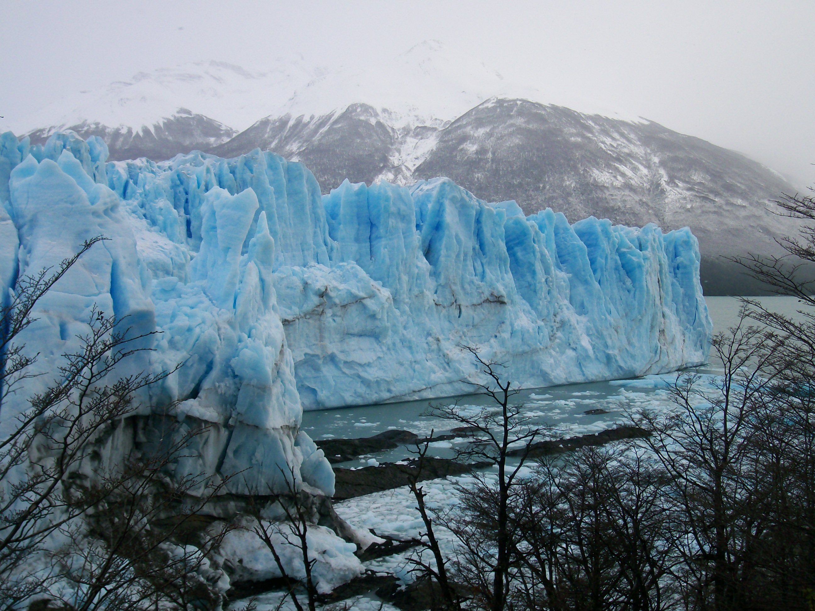
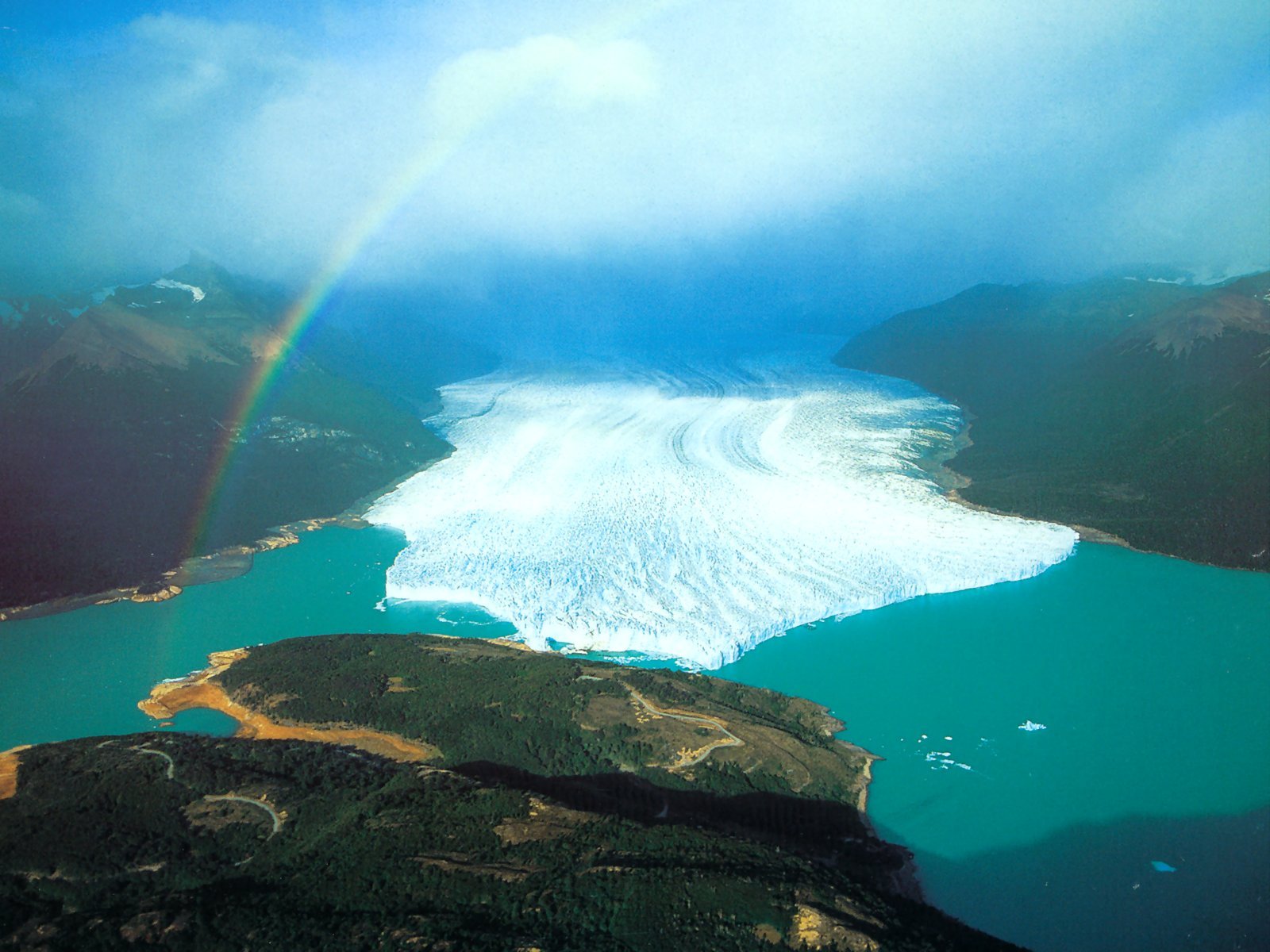
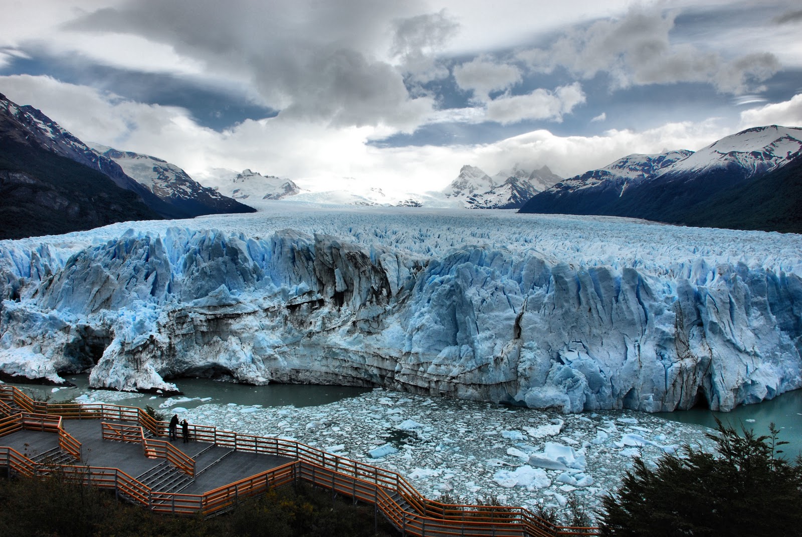
2. Perito Moreno Glacier, Argentina

There are as many as 13 glaciers in the Lago Argentino National Park, but the Perito Moreno Glacier is considered the most beautiful of them. The icy river, which is 60 meters high, divides the high-altitude Lake Argentino into 2 parts: the Rich Sea and the South Sea. Making their way through the glacier along the canal, the waters of these seas gradually destroy it, and thanks to this tourists can admire the view of huge blocks of ice falling into the water. On the territory of the reserve you can meet guanacos, rhea ostriches and even the condor - the largest bird in the world.
3. Glacier Bay, Alaska

Glacier Bay is a giant national park located on the southeastern coast of Alaska and is protected by UNESCO. There are practically no walking tours in the reserve; glaciers are inspected from an airplane or helicopter. However, you can watch the sparkling ice without leaving the hotel, which is located right in the park. In addition, icebergs that have broken off from the edge of the glacier and rearing ice blocks can be admired by taking a cruise along the coast. In the surrounding waters of the reserve you can stumble upon whales, walruses and even dolphins, and the coastal forests are home to bears and deer.
4. Furtwängler Glacier, Tanzania

Since the beginning of the century, the glacier located almost at the equator has been gradually melting and, according to scientists, by 2020 it will completely disappear. Furtwängler is located at an altitude of more than 5000 meters, on the northern side of Kilimanjaro, near its summit
5. Pasterze Glacier, Austria

The largest of Austria's 925 glaciers, the Pasterze is also gradually disappearing and is predicted to be less than half its current size by 2100. In the meantime, this 9-kilometer-long, seemingly motionless river of ice slowly descends from an altitude of 3,500 meters to the foot of Mount Glosgrokner.
6. Vatnajokull Glacier, Iceland

Iceland's largest glacier makes up approximately 80 percent of the island's total ice cover, which gets its name from the frozen water. Its huge fields, riddled with cracks, stretch over 8,300 square kilometers. The cold beauty of the ice is rivaled by the lava frozen in the intricate curves of the nearby volcanic landscape. Favorite activities for tourists: descending into ice crevices, rock climbing on a glacier, snow rafting and swimming in the thermal springs of ice caves.
7. Yulong Glacier, China

Scientists have more than once predicted the disappearance of China's southernmost glacier, but systematic observations of its movement, which have been carried out since 1982, refute pessimistic forecasts: depending on climate fluctuations, the glacier retreats several hundred meters upward, then descends again. The lower boundary of the glacier is currently located at an altitude of about 4200 meters above sea level, and getting to it is not so easy due to the very rarefied air.
8. Fox and Franz Joseph Glaciers, New Zealand

The glaciers flowing like a frozen waterfall from the western slope of the Southern Alps come so close to the subtropical evergreen forests that their proximity seems completely unnatural.
9. Athabasca Glacier, Canada

Another rapidly melting glacier, considered the most beautiful in North America, has recently lost almost half of its volume. Currently it is only about 6 kilometers long. Such rapid melting has resulted in the fact that the glacier is constantly in motion and therefore it is strictly forbidden to walk along it alone, without a guide.
10. Antarctic

And, of course, the most ice and snow can be seen in Antarctica, which probably became the reason for the increased popularity of the continent due to global warming. If in the 90s 6-7 thousand people came here during the season, then last year the number of tourists reached 45,000, and therefore the number of incidents harming the ecology of the region increased. Therefore, quite recently, 28 countries conducting scientific activities in Antarctica signed an agreement to limit tourism to the mainland.
2016-06-22The most unique, famous glaciers.
The glacier is approximately 62 km long, making it the longest glacier in the world outside the polar regions. The glacier is located in the Gilgit-Baltistan region of Pakistan. Baltoro is surrounded by the Karakoram Mountains and is located between the Baltoro Muztagh ridge from the north and the Masherbrum ridge from the south, the highest mountain in the area is K2 (8611 m). The lower part of the glacier is located at an altitude of 3400 m above sea level, followed by the melting zone of the glacier, which gives rise to the Biafo River.
Antarctica contains the largest amount of ice, and therefore the largest amount of fresh water on the planet. The maximum thickness of ice on the continent is 4800 meters, the average thickness of ice covering the continent is 2600 meters. Moreover, in the central part of Antarctica the ice thickness is greater, and towards the coast it is less. The ice seems to flow from the continent into the ocean. When the ice reaches the ocean, it breaks off into large pieces called icebergs.
The volume of glaciers is 30,000,000 square kilometers, which is 90% of all ice on the planet.
The Kilimanjaro Glacier is not one of the largest glaciers, but its uniqueness is that it is located near the equator in Africa. The Mount Kilimanjaro glacier was formed 11,700 years ago. Since 1912, observations have been made that the area of the glacier began to gradually decrease.
By 1987, the glacier's area had decreased by more than 85% compared to 1912.
Now the absolute area of the glacier is less than 2 square meters. km. According to scientists, the glacier will completely disappear by 2033.
Aletsch Glacier
The Aletsch Glacier is the largest glacier in the Alps. Its length is 23 km, the area of the glacier is 123 square kilometers. The glacier includes 3 adjacent small glaciers. The maximum ice depth is 1000 meters. The glacier has been a UNESCO World Heritage Site since 2001 (site no. 1037bis).
 |
 |
 |
Harker Glacier is located on South Georgia Island in the South Atlantic Ocean. The uniqueness of the Harker Glacier is its method of formation. This glacier is a tidal glacier. Discovered in 1901 by a Swedish expedition led by Otto Nordenskiöld and Karl Anton Larsen. The glacier is quite stable in its area and volume, although its outline changes over time.
Jostedalsbreen Glacier
The Jostedalsbreen Glacier is the largest glacier in continental Europe. The length of the glacier is 60 km, the area is about 487 square kilometers. Like most other glaciers in the world, Jostedalsbreen is gradually decreasing in size and volume. In 2006, one of the glacier's branches shrank by 50 meters in a few months.
Vatnajökull Glacier
The Vatnajökull glacier is located in Iceland, it is the largest glacier in Europe, so its area is 8100 square kilometers, the volume of the glacier is estimated at 3100 cubic kilometers. The glacier covers volcanoes, and inside the glacier there are caves formed by geysers - hot springs of water. The maximum ice thickness is about 1000 meters.
Hubbard Glacier is located on the border of Alaska and Canada. The glacier was discovered in 1895. The length of the glacier is 122 kilometers. The glacier ends up in Yakutat Bay. The height of the ice in the bay reaches 120 meters above sea level, the width of the glacier near the bay is from 8 to 15 kilometers, depending on the time of year.
The Franz Josef Glacier is located in New Zealand. The glacier is 12 kilometers long and was discovered in 1859. The glacier has phases of increase and decrease; after 2010, it entered an active phase of decrease (retreat).
 |
 |
 |
The Perito Moreno Glacier is located in the southwestern part of the province of Santa Cruz, Argentina.
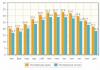
The length of the glacier is about 30 km, the area of the glacier is 250 km. square. The glacier moves along the mountain slopes to Lake Argentino at a speed of about 2 meters per day. Periodically, a glacier covers the lake, dividing it into 2 parts. The water in the southern part of the lake, due to rivers and streams, begins to rise compared to the northern part. The difference in levels is more than 30 meters, under the influence of water pressure, the isthmus collapses, and streams of water rush into the northern part of the lake.
American researchers from the U.S. Environmental Protection Agency (EPA) calculated that over the century (since 1913) the average temperature on Earth has risen by half a degree Celsius. As a result, some ice has melted in the Arctic and Antarctic. And This caused the level of the world's oceans to rise by almost 20 centimeters.
Ice now covers 10 percent of the Earth's surface.
Its volume, according to rough estimates, is 9 million cubic kilometers. What happens if all this frozen water melts? What will our planet look like after the flood?
The post-flood land is depicted on National Geographic maps; The white line indicates the boundaries of the land before the flood.
Antarctica


Australia


North America

South America

You have no rights to post comments
In glaciology, there has long been a tendency to distinguish between the concepts of cover and mountain glaciations, cover and mountain glaciers [Koryakin, 1981] and even to distinguish sections of cover and mountain glaciology. However, the cover glaciers of Antarctica and Greenland cannot be spoken of as anything other than mountainous, since they form high-elevation ice plateaus up to 4000 m (with individual peaks up to 5140 m) in Antarctica and 3700 m in Greenland, where the ice covers plateaus and mountain ranges . The ice cover of Antarctica reaches a thickness of more than 4300 m (average 1720 m), Greenland 3400 m (average 2300 m). True, in a significant part of Antarctica there is no real mountainous terrain with its deep dissection; an ideal, highly elevated ice plain spreads over vast areas. But the point is not only that individual sections of this plain on geographical maps are called plateaus (Polar Plateau, Sovetskoe Plateau and a number of others). In accordance with the criterion for separating mountain landscapes from flat ones, the nival-glacial landscapes of Antarctica cannot be classified as flat: there is no latitudinal-zonal change in landscape types, which would be at lower absolute altitudes, and it actually exists on the Antarctic coast, where in the free seas In ice areas, oases are located with non-glacial landscapes of polar (Antarctic) deserts, and not with a nival-glacial landscape. E. S. Korotkevich especially emphasizes the disruption of the latitudinal zonation of Antarctica by altitudinal zonation (zonation), which is especially pronounced here, and considers this continent as a glacial massif with a single vertical zonation. The same applies to Greenland, where the coastal landscapes in the middle and southern parts of the island are even polar and subpolar (subarctic). Undoubtedly, the cover glaciers of Novaya Zemlya, as well as the ice sheets of the Arctic lowlands of Severnaya Zemlya, also belong to the mountain glaciers in the physical-geographical sense. Where the ice covers mountain ranges with sharp peaks or plateaus with outliers rising above the main plateau-like surface, in places, mainly along the outskirts of the ice sheet, lonely rocks called nunataks protrude from under the ice onto the day surface. Parts of the ice sheet, identified as outlet glaciers, flow down depressions of the subglacial surface towards the seas and oceans. Most of them received their own geographical names. They reach the coasts, break off there and give rise to floating ice islands - icebergs.
In Greenland and Novaya Zemlya, individual glacial streams descend from ice sheets into deep fjords and form fjord glaciers. In previous classifications of glaciers, ice sheets were identified as continental ice sheets or Greenland-type glaciers [Kalesnik, 1939]. In general, we are against the use of our own geographical names to designate types in classifications of geographical phenomena according to their properties (typological classifications). But since such names are in some cases firmly rooted in the literature (or the corresponding types actually have local specifics), in some cases they will have to be used. Glaciers like the Antarctic, Greenland, Novaya Zemlya, etc., are now distinguished under the name of ice sheets, separating ice sheets from them (in mountainous areas), when the subglacial relief is reflected in a softened form in the surface of the glacier. An intermediate link between mountain and cover glaciation is reticulated glaciation (related to mountain cover glaciation), which occurs when there is very abundant nutrition, when ice, having filled the valleys, begins to flow through depressions in individual ridges. Sometimes this glaciation is called the Svalbard-type glacier, which was identified by Nordenskiöld. However, it is more correct to talk about the Svalbard glaciation, which includes a wide variety of types of individual glaciers. The specific features of the morphology of glaciation in the Spitsbergen archipelago are determined by the degree of its development at the stage between mountain and cover. Glaciation of this kind is common only in the polar mountain ranges, except for Spitsbergen in Alaska, Novaya Zemlya, and southern Patagonia. Among the mountain glaciers themselves, closely related to the mountainous terrain, which determines the shape and direction of their movement, glaciers of peaks, slopes and valleys are distinguished. In the series of valley glaciers, in addition to simple valley glaciers, complex valley and dendritic glaciers are distinguished.
Double and complex valley glaciers are composed of two or more branches. Dendritic, or tree-shaped, glaciers resemble a branched tree in plan. In the latter case, abundant snow feeding leads to the fact that the glaciers of the side valleys (tributaries) connect with the glacier located in the main valley. This type includes large valley glaciers of the mountains of Central and Central Asia, in particular the Karakoram and the Himalayas, as well as mountains of high latitudes. With a large influx of solid atmospheric precipitation into the feeding area of a valley glacier, an increase in its thickness leads to the fact that the glacier does not fit in the mountain valley and moves out onto the foothill (or intermountain) plain.
Then a foothill glacier of the Malaspina type is formed. Flat-top glaciers appear on highly elevated, leveled surfaces. Two subtypes can be distinguished here: glaciers with tongues spreading in different directions along steep-walled deep valleys (Scandinavian subtype) and flat-top glaciers themselves without significant ice tongues, often completely devoid of them (Tien Shan subtype). Cone glaciers form on conical mountain elevations, most often of volcanic origin. The ice and firn covering the cone create a kind of cap, from which the tongues of individual glaciers, known under their own geographical names, descend radially. This type includes the Caucasian glaciers of Elbrus, Kazbek and glaciers of many other volcanoes. The glaciers of the tops of young volcanic cones, not dissected by valleys and cirques, are called star-shaped. Caldera glaciers are found in the craters of volcanoes [Kalesnik, 1939]. Often in the mountains there are hanging glaciers, which come in two subtypes: cirque-valley, located in a cirque, but beginning to slide from the cirque into the valley, and hanging glaciers, which are not associated with any clearly defined depressions, but use only the gentle concavity of the slope. Hanging glaciers themselves usually end high on the slope, as if glued to it with their entire mass [ibid., p. 216]. Apparently, glaciers that cover the wide and gentle slopes of the mountains in the eastern part of the Gissar-Alai (Surkhob basin) and in the Eastern Pamirs with a thin (several tens of meters) layer are close to this subtype. V. M. Kotlyakov called them slope glaciers. There are very numerous cirque glaciers in the mountains, small ones that form in bowl-shaped depressions (cirques) on the slope of a ridge or in the upper reaches of a valley. They are deprived or almost deprived of the glacial tongue as such, which is common in the valleys. Wind-blown glaciers form in negative relief forms and on the leeward side of elevations from wind-blown snow, which in polar and subpolar latitudes does not have time to melt during the summer. They arise at the bottom of rocky ledges of terraces, at the back walls of ravines, in narrow shaded gorges and consist of firn and firn ice. For a long time, it was believed that the ice of moving glaciers very actively erodes the underground bed (this process is called glacial erosion or gouging) and the presence of piles of stone blocks (moraines) in front of the front of a moving glacier was cited as one of the evidence. In the late 1940s and 1950s, it was believed that the bulk of the clastic material forming modern moraine deposits came from the surfaces of the slopes rising above the glacier.
The role of the bottom moraine is negligible, and there is no reason to talk about the glacier as a factor that effectively erodes. However, now the essential excavation work of moving ice has been restored again. New studies based on modern methods indicate that the plowing activity of mountain glaciers is comparable in intensity to water erosion, and the main moraine material enters the glaciers not only from the surrounding mountain slopes, but to a large extent also from the glacial bed. At the beginning of the previous section, the chionosphere is mentioned. This is a part of the troposphere within which, given favorable terrain features, accumulations of snow, firn and ice can form, i.e., glaciers can form [Kotlyakov, 1968]. Many mountains protrude beyond the lower boundary of the chionosphere, and that is why glaciers originate on them. The thickness of the chionosphere, apparently, lies within 3–5 km and varies relatively little over different parts of the earth’s surface [ibid., p. 137]. Even the highest mountains probably do not reach the upper boundary of the chionosphere. In any case, they cannot reach it in low latitudes, where the highest mountain elevations of the Earth are located (the Himalayas and Karakoram, the Andes), since there the lower boundary of the chionosphere, indicated by the snow line, is raised very high. It is believed that the line of intersection of the lower boundary of the chionosphere with the mountain slopes is the climatic snow line [Shchukin, Shchukina, 1959, p. 66]. However, the snow line does not completely coincide with the boundary of the chionosphere. The snow line is the most important glacioclimatic indicator, reflecting the connection between glaciation and climatic conditions. Its height, which largely determines the intensity of glaciation in the region (the relationship here is the opposite), is associated with geographic latitude (and, therefore, with the thermal resource), as well as the degree of continental climate. In polar latitudes, the snow line is located within the low-mountain layer (Svalbard altitude 200,370 m on the windward slopes, 250,800 m on the leeward). Under the tropics it rises to 6000 m or more: in the Andes of South America near the tropic in the south of Puna and in the Pampinsky Sierras it exceeds 6500 m (the highest position in the world). At the equator, its height is 5300-5400 m. At the same high altitude there is a snow line on the most continental highlands of the subtropical zone, for example in the Eastern Pamirs (up to 5200 m). It turned out, however, that in the Eastern Pamirs, the dry climate of which was judged by data from weather stations located on the flat bottoms of valleys and basins with a height close to 4000 m, and showing an annual rainfall of only 100 mm, in the uppermost tier of the mountains, in their glacial zone, 800-1000 mm of precipitation falls per year, which is very much for such a generally dry area.
Totten is one of the largest glaciers within East Antarctica, and the most voluminous mass of ice in the world. Given that 2016 was named one of the hottest years, is it any surprise that scientists claim that Totten has begun to melt at a record speed?
Extent of melting
An international team of researchers published a report in the journal Science Advances that says abnormally warm ocean water is pouring into the base of the glacier at a rate of 220,000 cubic meters per second. This is enough to cause the melting of 73 billion tons of ice per year.
The melting of huge glaciers like Totten is contributing to rapid sea level rise. To make matters worse, meltwater from the glacier destroys the ice at the edge of the continent, and more water flows freely into the sea. 
The ice area of the Totten catchment is the size of Spain. If all this ends up in the ocean, global sea levels will rise by 3.5 meters.
Scientists' work
Scientists from the University of Tasmania and the University of Texas at Austin were able to collect this data by sending their research vessel into one of the crevices carved into the seashore. Once under Totten, they were able to see the extent of the erosion in real time for the first time. 
Like many of Greenland's glaciers, Totten is being eroded from below by increasingly warmer and more acidic seawater. This is directly related to the accumulation of greenhouse gases in the oceans. Warm water always leads to glacier erosion, but there are certain structural configurations that increase the likelihood that the entire ice structure will collapse. 
How does erosion occur?
The Totten Glacier is deeply rooted below sea level. It is located on a relatively solid rock base. In some places this rock is flat, but in others its slopes are quite steep. If the underbelly of a glacier erodes at a point where it is solely on a sloping area, it will begin to move at an abnormal speed. 
A sloping zone may be found in the middle of the glacier's current region, a recent study has shown. The last time the glacier was balanced was about 3.5 million years ago. At that time, the level of carbon dioxide in the atmosphere was about 400 parts per million, which is identical to what is observed today. 
So this is truly terrible news. This huge glacier is really falling apart and may soon begin its inexorable and irreversible slide into the sea. At least this should convince skeptics who believe climate change is a hoax.
Glaciers are an extraordinary miracle of nature that slowly moves across the surface of the Earth. This accumulation of eternal ice captures and transports rocks along its path, forming unique landscapes such as moraines and karas. Sometimes the glacier stops moving and the so-called dead ice forms.
Some glaciers, moving a short distance into large lakes or seas, form an area where they break up and, as a result, drift icebergs.
Geographical feature (meaning)

Glaciers appear in places where the accumulated mass of snow and ice significantly exceeds the mass of melting snow. And after many years, a glacier will form in such a region.
Glaciers are the largest reservoirs of fresh water on Earth. Most glaciers accumulate water during the winter season and release it as meltwater. Such waters are especially useful in mountainous regions of the planet, where such water is used by people who live in areas where there is little precipitation. Glacier meltwater is also a source for the existence of flora and fauna.
Characteristics and types of glaciers

According to the method of movement and visual outlines, glaciers are classified into two types: cover (continental) and mountain. Ice sheet glaciers occupy 98% of the total area of planetary glaciation, and mountain glaciers occupy almost 1.5%
Continental glaciers are giant ice sheets located in Antarctica and Greenland. Glaciers of this type have flat-convex outlines that do not depend on the typical topography. Snow accumulates in the center of the glacier, and consumption occurs mainly on the outskirts. The ice of the cover glacier moves in a radial direction - from the center to the periphery, where the ice that is afloat breaks off.
Mountain-type glaciers are small in size, but of different shapes, which depend on their content. All glaciers of this type have clearly defined areas of feeding, transportation and melting. Nutrition is carried out with the help of snow, avalanches, a little sublimation of water vapor and snow transfer by the wind.
The largest glaciers

The largest glacier in the world is the Lambert Glacier, which is located in Antarctica. The length is 515 kilometers, and the width ranges from 30 to 120 kilometers, the depth of the glacier is 2.5 km. The entire surface of the glacier is cut by a large number of cracks. The glacier was discovered in the 50s of the twentieth century by the Australian cartographer Lambert.

In Norway (Svalbard archipelago) there is the Austfonna glacier, which leads the list of the largest glaciers in the Old Continent by area (8200 km2).

(Vatnajökull Glacier and Grimsuod Volcano)
In Iceland there is the Vatnajökull glacier, which ranks second in Europe in terms of area (8100 km2). The largest in mainland Europe is the Jostedalsbreen glacier (1230 km2), which is a wide plateau with numerous ice branches.
Melting glaciers - causes and consequences

The most dangerous of all modern natural processes is the melting of glaciers. Why is this happening? The planet is currently heating up - this is the result of the release of greenhouse gases into the atmosphere that are produced by humanity. As a result, the average temperature on Earth also rises. Since ice is the repository of fresh water on the planet, its reserves will sooner or later run out with intense global warming. Glaciers are also climate stabilizers on the planet. Due to the amount of ice that has melted, salt water is evenly diluted with fresh water, which has a special impact on the level of air humidity, precipitation, and temperature indicators in both the summer and winter seasons.