The largest state on the planet, Russia, has about 50 operating national parks on its territory. Most of them are located in the European territory of the country. One of the rich natural places of our state is the Mari Chodra National Park, the attractions of which will be discussed in the article.
General information about the park
The Mari Chodra National Park is located on the territories of the Morkinsky, Zvenigovsky and Volzhsky districts in the Mari-El Republic, which is a subject of the Russian Federation. The area of the park is 366 square kilometers. It was created in 1985 with the aim of protecting rare plant species, of which there are more than 100, from extinction. A photo of the Mari Chodra National Park can be seen in the article.
There are about 15 tourist routes in the park. The main attractions of the Mari Chodra National Park are lakes, for example, Yalchik, Glukhoe, Kichier, as well as the Ilet and Yushut rivers. One of the places frequently visited by tourists is Pugachev's Oak. Tourism in the park plays an important economic role for the republics of Mari-El, Tatarstan and Chuvashia.

The state organization FSBI Mari Chodra National Park controls and carries out tourism and security activities in the park. The property of this organization is a number of natural objects and complexes located in the Middle Volga region.

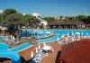
Perhaps this is one of the favorite places for tourists who come to relax in the territory of the Mari Chodra National Park. There are several recreation centers on the shores of the lake that provide rental services for boats, bicycles and other equipment. According to tourists, there is a beautiful sandy beach with a magnificent view of the shores of the lake, and the areas of the recreation centers are quite well-groomed and there are shops. Tourists also speak positively about the food, which is varied and tasty.
Lake Yalchik is one of the largest natural reservoirs in the park. It consists of two small lakes connected by a bridge. In the summer, when the region is hot, this bridge often dries up, completely separating one lake from another. The waters of Yalchik are home to perch, pike and other types of fish, so for fishing enthusiasts, visiting one of the recreation centers on the shores of Yalchik will be a good choice.
Ilet River
This is one of the popular tourist spots in the Mari Chodra National Park. The river has a length of more than 200 km, most of it is located within the park. The river itself is not wide (several tens of meters), the banks of the upper Ilet are steep, and the banks of the middle and lower reaches are flat, and sandy beaches are often found on them. Surrounded by mixed forests.

The Ilet River is famous for the fact that lovers of active recreation come to it to raft along it, mainly on kayaks and catamarans. The river flow is calm at a speed of 3-6 km/h, so it is well suited for beginner kayaking enthusiasts. There are several routes for rafting along the river, their length ranges from 20 to 90 km.
Pugachev Oak

It is perhaps impossible to imagine a holiday in the Mari Chodra Park without excursions to Maple Mountain, where the oak tree grows. The peculiarity of the oak tree is its size and age, so the diameter and height of the tree are 1.59 m and 26 m, respectively, and the age, according to modern estimates, more than 400 years. A stone was placed near this giant, on which there is an inscription testifying to the events that took place in the second half of the 18th century on Maple Mountain.
According to one legend, Emelyan Pugachev himself climbed this oak tree before making a trip to Kazan. According to another legend, the leader of the uprising climbed a tree after the defeat near Kazan to watch it burn in flames. In any case, it is reliably known that Pugachev’s detachments were in the summer of 1774 in the forests near Maple Mountain.
As for Pugachev's Oak itself, he could have witnessed the uprising, but Pugachev could not climb it, since at that time the tree was still too small. It is believed that Emelyan Pugachev, if he climbed a tree, it was another oak tree, which was even larger than the existing one. It dried up long ago and was cut down in the 40s of the 20th century.
Currently, excursions to the Pugachev Oak are carried out both in the summer on bicycles and cars, and in the winter on skis.
The park was formed in 1985 to preserve the standard natural complexes of the Republic of Mari El. Translated from the Mari language, “Mari Chodra” means “Mari forest”. The entire territory of the park is covered with beautiful pine forests and coniferous-deciduous forests. The decoration of the park is clean and beautiful karst lakes, many of which are declared natural monuments. The attractiveness of the park is the abundance of mineral springs. The largest of them is the Green Spring, the water of which is used in treatment.
Relief
The territory of the park is formed by the southern spurs of the Mari-Vyatsky Uval. The southwestern part of the park is adjacent to the river. Volga. Most of the territory belongs to the Iletsky upland-plain southern taiga region with the development of modern karst, the smaller part belongs to the Polesie valley-terrace lake region of mixed forests. The park area is a gently undulating plain with island uplands (Kerebelakskaya, Klenovogorskaya), with absolute heights of 75–125 m above sea level. m. The highest absolute elevation of the territory is the peak of Maple Mountain - 196.0 m above sea level. m. The active manifestation of the karst process led to the development of karst landforms - numerous sinkholes, up to 50–60 m in diameter, and sinkhole-type lakes, up to 35–40 m deep.
Hydrology
Lakes. The park contains a significant number of picturesque lakes of karst origin. Most of them are declared natural monuments, Glukhoye, Kichier, Yalchik, Ergezh-Er, Shut-Er, Kuzh-Er, Shungaldan. They are round or oblong in shape, up to 40 m deep, with a silt bottom. The lakes are fed by springs or small rivers and streams. Some of them have underground connections with neighboring rivers.
Lake Glukhoe is located 4 km east of the village. Yalchinsky. The shores of the lake are relatively high, steep, and covered with forest. The area of the lake is 22.0 hectares, maximum depth 23 m, length 2140 m, width 100 m. The water is dark, brownish in color. The bottom of the lake is dense, partly sandy or limestone.
Lake Kichier is located in the Yalchin forestry. The shores are flat, sandy, and slightly swampy in places. The area of the lake is 46.0 hectares, maximum depth 16 m, total length 3 km. Consists of three interconnected swimming pools. The water is dark. The bottom is muddy. The sludge is dark, black, with the smell of hydrogen sulfide.
Lake Yalchik is located in the Yalchinsky forestry. It consists of a central large basin and three adjacent ones, connected to it by narrow and shallow straits. The shores of the lake are mostly sandy and only silty in places. The highest and steepest are the eastern and northern shores. The lake is surrounded on almost all sides by mixed forest with a predominance of pine. The area of the lake is about 150 hectares, the maximum depth is 35 m. The water is clear. The bottom is sandy.
Lake Ergezh-Er (translated from Mari as Round). Located in Kerebelyak forestry. It is part of the system of karst lakes located at the foot of the ledge of the Kerebelyak Upland. The area of the lake is 4.5 hectares, maximum depth 13 m, length 350 m, width 150 m. The water is clear. Bottom sediments are insignificant.
Lake Shut-Er (translated from Mari, Black). Located in Kerebelyak forestry. It is part of a system of karst lakes located at the foot of the ledge of the Kerebelyak Upland along its eastern steep slope. The area of the lake is 28.9 hectares, maximum depth 17.5 m, length 1550 m, width 300 m. The water is dark in color. Bottom sediments are insignificant. The diet is mixed (groundwater, springs, swamps). The banks are high, but not steep.
Lake Kuzh-Er (translated from Mari as Long). Located in Kerebelyak forestry. It is part of a system of karst lakes located at the foot of the ledge of the Kerebelyak Upland along its eastern steep slope. The area of the lake is 25.0 hectares, maximum depth 26.5 m, length 1300 m, width 200 m. Water transparency 4 m. It is fed by groundwater, partly by the springs of the western shore. Bottom sediments are insignificant. The northern and southern shores are swampy. The western bank is high (about 40 m). A channel flows from the northern corner of the lake and flows into the lake. Yergezh Er.
Lake Shungaldan is located 1.5 km from the Green Key mineral spring, on the left bank of the river. Fly. The lake is oval in shape, of sinkhole origin, with marshy shores. The hydrogen sulfide content in water reaches 50–75 mg per 1 liter, which gives the water valuable medicinal properties for external use in the form of baths.
The Green Key mineral spring is located at the foot of Klenovaya Gora, 1.8 km from the mouth of the river. Yushut. The water of the source rises from the bottom of a funnel, the diameter of which is about 2 m, and partially flows out from under the base of Klenovaya Gora, connecting into one stream, up to 6 m wide and 0.7–0.8 m deep. It flows into the river. Fly. Water consumption from 1000 to 1540 l/s. The water temperature is constant throughout the year and is 6.5°C. The chemical composition of the water is calcium sulfate.
Rivers. The main river of the park, Ilet, crosses it from northeast to southwest and flows into the Volga. Its left bank tributaries are the river. Yushut, Arbaika, Uba. The river flows into it on the right. Petyalka. The silt flows through a plain with slightly undulating terrain, covered with mixed forests, its speed is 0.2–0.8 m/s. In winter the river does not freeze. The river bed is winding, composed of limestone and sand, subject to deformation, the banks are flat and swampy in places. The width of the channel reaches 20–40 m.
The floodplain of the Ilet River is two-sided, up to 500 m wide, overgrown with shrubs and mixed forests. In its floodplain and tributaries there are about 200 oxbow lakes, where beavers, minks, muskrats, otters live, waterfowl nest, and fish live. Many of the oxbow lakes are rich in healing mud. During the warm period of the year, the river's water content allows tourist boats to pass through.
Soils
The soil cover is varied due to differences in topography and underlying rocks. The most common soils (81% of the park area) include podzolic and soddy-podzolic soils.
Climate
The climate of the park is moderate continental. It is characterized by relatively hot summers and frosty winters with stable snow cover. The average temperature of the warmest month of July is 18.6°C. The absolute minimum air temperature in winter reaches -52 C. The average duration of the warm period of the year with temperatures above 0°C is about 200 days.
The territory of the park belongs to a zone of unstable moisture: there are years with sufficient, sometimes excessive moisture, but there are also dry years. Precipitation falls unevenly throughout the year: the greatest amount is observed in summer, the least in winter. An average of about 500 mm of precipitation falls annually. The highest monthly precipitation is observed in July – 60–70 mm. The invasion of cold air masses from the polar basin with northern, northwestern and northeastern winds causes a sharp drop in temperature in winter, and frosts in spring and autumn. Continental air masses from the southeast often invade the park territory. In spring or summer they cause dry conditions, in winter – clear, frosty weather.
MARI CHODRA, national park in the Republic of Mari El. Founded in 1985. Sq. 36.6 thousand hectares. Located in the river basin. Ilet (left tributary of the Volga) in the southern part of Vyatsky Uval. Karst. Coniferous broadleaf forests. The fauna includes elk, squirrel, chipmunk, hare... ...Russian history
National park in the Republic of Mari El. Created in 1985 on the square. 36.6 thousand hectares for the protection of coniferous-deciduous forests of the Volga region (pine, linden, alder, oak, birch) in the river valley. Fly. 1155 plant species, of which about 10% are rare and... ... Geographical encyclopedia
Coordinates: 56°42′ N. w. 47°52′ E d. / 56.7° n. w. 47.866667° E. d. ... Wikipedia
Republic of Mari El Mari El Republic of Mary El Republic ... Wikipedia
Republic in Volgo-Vyatka economic. area. Pl. 23.2 thousand km², capital Yoshkar Ola; other large cities: Volzhsk, Kozmodemyansk. Formed in 1920 as the Mari Autonomous Republic. region, since 1936 – Mari Autonomous Soviet Socialist Republic, since 1990 – Republic of Mari El. Located… … Geographical encyclopedia
Main article: Mari El As of January 1, 2011, the natural reserve fund of the Republic of Mari El includes 49 specially protected natural sites (SPNA), including: State Nature Reserve "Bolshaya Kokshaga"; National... ... Wikipedia
This term has other meanings, see Volzhsky region. Volzhsky district Yulser kundem Coat of arms ... Wikipedia
MARIY CHODRA
national park
Location and history of the Mari Chodra National Park
National Park "Mari Chodra" in 1985 on the territory of the Republic of Mari El. The national park is located in the southeast of the Mari El Republic, in its most economically developed part, on the territory of three administrative districts: Morkinsky, Zvenigovsky, Volzhsky. There are 5 settlements in the park, home to about 15 thousand people.
The area of the national park is 36.6 thousand hectares, all lands are provided to the national park. Forest lands occupy 34.0 thousand hectares (92.9% of the park), incl. covered with forest - 33.5 thousand hectares (91.5%). Non-forest lands occupy only 7.1% of the park's territory, among them: hayfields, pastures, arable lands - 1%, water - 2%, swamps - 1%, roads and clearings - 2%, the rest - estates and other lands. The national park is located 60 km from the city of Yoshkar-Ola and 30 km from the city of Volzhsk. Its territory is crossed by the Yoshkar-Ola - Moscow railway and the Yoshkar-Ola - Kazan highway of republican significance.
Nature of the Mari Chodra National Park
The flora and vegetation of the park are diverse. Its territory is located on the southern border of coniferous-deciduous forests of the subtaiga zone, and in floristic terms, at the junction of the European and West Siberian provinces of the Euro-Siberian floristic region. The flora of this limited area includes 774 species and subspecies from 363 genera of 93 families, which is more than 67%. A number of taiga species, both European (Norway spruce) and Siberian (Siberian fir), are found here with elements of forest-steppes (summer oak) and steppes (feather feather grass). Pine forests grow mainly on sandy and sandy loam soils and make up 27.7% of forests. Among them, pure green moss pine forests predominate, often with the participation of aspen, birch, and sometimes spruce. A special place belongs to sphagnum pine forests. Although their area is only about 600 hectares, they are an important component of the park's natural complex. Spruce forests are presented mosaically and occupy only 3.3% of the forest area. They may contain pine, birch, and aspen.
The park's flora includes about 50 rare species, which makes up 1/4 of the list of rare and endangered species of local flora. Among the species listed in the Red Book of the USSR (1984), there are the true slipper and the red pollenhead. Relict plants can be seen in sphagnum bogs: swamp chamarbia, Magellanic and stringroot sedges, white sphagnum, cotton grass, sundews. Some plant species have become endangered as a result of the disappearance of plant communities. For example, from the swamps - swamp moth, unifoliate grasshopper, compressed streamweed, Lapland willow, and from the field - common cockle. As a result of intensive exploitation, the endangered species include sandy cinnamon, pure white water lily, curly lily, Siberian iris, etc.
Animals of the Mari Chodra National Park
The park is home to many animals from the mixed forests of the European part of Russia. This is due to the ecological and trophic diversity of habitat conditions, as well as the geographical location of the park at the junction of natural zones. The fauna of the republic is quite well studied. However, a systematic study of the fauna of the national park has not yet been carried out. But if we exclude species that live in ecotopes that are not typical for the park (the forest-steppe part of the republic, the Volga valley, the Cheboksary reservoir), then it should be assumed that approximately 50 species of mammals, about 100 species of birds and 29 species of fish live in its lands.
Among mammals, the most numerous order is rodents. In the forests of the park, the squirrel and chipmunk, a recent eastern newcomer, are found in the squirrel family; from the mouse family - wood mouse, bank vole, yellow-throated mouse, etc. From the order of lagomorphs, the white hare is not uncommon, and the brown hare is occasionally found along the borders with fields. The order of carnivores is represented by the mustelid family: weasel, ermine, polecat, pine marten, European and, possibly, American mink - all are relatively small in number. The otter noted by Yushut is especially rare. Interestingly, mink sometimes hunts birds, in particular hazel grouse, by their voice. Of the felines, the lynx apparently enters. Elk are common in forests. Another representative of the artiodactyl order, the wild boar, is less common. In the lands of Mari-Chodry, especially in the Ileti floodplain, many bats live in hollows in overmature forests. Specially protected species include the otter and the beaver, which were brought from the Voronezh Nature Reserve and released into the republic’s lands in 1947. Interestingly, beavers were previously found on the Irovka, a tributary of the Ilet, but were exterminated.
The most common birds are passerines, whose life is associated with forests: jay, magpie, oriole, crossbills, pika, nuthatch, tit, etc. Birds from the order of woodpeckers should also be included here: great and lesser spotted woodpeckers, and the common woodpecker. In mixed forests with varied and dense undergrowth, representatives of the thrush family are common: field thrush, mistletoe, blackbird. Forest birds leading nocturnal and twilight lives, although less common, include the long-eared owl, the hawk owl, the great owl and the largest of the owl family, the eagle owl. The common nightjar is common. Among the grouse birds in the park, taiga species live: capercaillie (unfortunately, their numbers have sharply decreased) and hazel grouse. A resident of the forest-steppe and broad-leaved forests, the black grouse, lives in clearings and young growth. From the snipe family, woodcock is common; snipe and great snipe are less common due to the limited meadow-marsh spaces. The pigeon family is represented by the wood pigeon, the pigeon and the dove. The first two live in old oak forests on Maple Mountain and feed on acorns. The most common diurnal birds of prey are the buzzard, goshawk, and black kite. No nesting eagles were found. But flights of the golden eagle, the largest eagle, are possible. Another rare feathered predator - the osprey - was noted along the river. Ilet, a little south of the park. Until recently, gray herons lived in the park: two pairs of herons nested in huge pine trees on the banks of the Ileti. Currently there are none. Of the waterfowl nesting birds in floodplain lakes and swampy channels, the mallard duck and teal are common; they are less common in reservoirs of sinkhole origin. Possible habitat for the goldeneye, a typical wood duck that makes nests in hollows. Seasonal bird concentrations are small. In the fall, diving ducks temporarily stop on the lakes, and in the spring, the flight over the flooded rivers is busier. In autumn and winter, bullfinch, waxwing, sometimes nutcracker, etc. migrate.
Initial information about the national park was kindly provided by the administration of the resource www.biodiversity.ru
State Natural National Park "Mari Chodra" (meadow mar. Mari Chodyra, translated as "Mari Forest") is a national park in the southeastern part of the Mari El Republic, near the border with Tatarstan.
It is located on the territory of the Volzhsky, Zvenigovsky, Morkinsky districts of the republic.
Yoshkar-Ola is 60 km, Volzhsk is 30 km. A295 Yoshkar-Ola - Zelenodolsk - the M-7 Volga highway and the Zeleny Dol - Yaransk railway pass through the park.
The national park was established on September 13, 1985 by the Resolution of the Council of Ministers of the RSFSR on the basis of the Resolution of the Council of Ministers of the Mari Autonomous Soviet Socialist Republic of December 2, 1985 N 589 “On the creation of the Mari Chodra Natural National Park.”
The national park is located in the southern part of the Mari-Vyatsky shaft. Here it breaks up into separate hills. The terrain of the park is quite rugged, the soils are sandy. The network of rivers is well developed and there are many lakes.
Rivers:
The main river flowing through the Park is the Ilet. Almost all other rivers are represented by its tributaries: Yushut, Petyalka, Uba, Voncha, etc.
Lakes:
Mari Chodra is famous for its lakes.
Almost all of them are karst. All are popular summer holiday destinations among residents of Mari El, Tatarstan, Chuvashia and other, even more remote, regions of Russia.
Lakes: Yalchik, Glukhoye, Kichier, Melnichnoye, Teterkino, Mushan-Er, Konan-Er, Tot-Er, Shut-Er, Kuzh-Er, Ergezh-Er (Krugloye), Kugu-Er and others.

Flora
The vegetation cover consists of coniferous-deciduous forests. In the elevated areas, oak forests with maple, linden, and spruce are common; in the valleys there are mixed forests of spruce, pine, linden, oak, maple, aspen, elm, as well as floodplain oak forests.
There are pine forests with aspen, birch, and spruce. Minor areas are occupied by lowland grass swamps. About 50 plant species are considered rare for the flora of the Mari Republic.
Fauna
Common fauna include elk, squirrel, chipmunk, brown hare, weasel, ermine, polecat, pine marten, beaver (reacclimatized), and otter. There are also bears and wolves. Among the grouse birds, the grouse, wood grouse, and hazel grouse nest; among the diurnal birds, the buzzard, goshawk, and black kite nest, and the golden eagle flies in. Mallards and teal nest on the lakes.
Scientific activity
In addition to the constant study of the park, which is carried out by full-time employees, with the assistance of MarSU, various expeditions are periodically conducted and environmental camps are organized (for example, “Pink Dandelion”).
Recreation
Many places in the Mari Chodra National Park attract recreation lovers. Research shows that in some places uncontrolled recreation is damaging the environment and access to these sites should be limited.
An environmental fee is collected from vehicles at the entrances to the park.
Main vacation spots
Yalchik:
Yalchik is the most popular and most accessible in terms of transport (buses to the turn on the P 175 highway, the Yalchevsky railway stop and minibuses directly to the bases) vacation spot.
There are 11 recreational facilities on the lake: Rubin recreation center (from the MMZ plant), det. camp Zheleznodorozhnik (from the Kazan branch of the State Railway), sports. camp Polytechnic (from MarSTU), boarding house "Yalchik" children. camp named after Vali Kotika, tourist center "Yalchik", SOL "Chaika" (from the Pedagogical University), SOL "Olympian" (from MarSU), recreation center "Yalchik", etc.
Kichier:
The Kichier sanatorium has been established on the lake, as well as the Republican Hospital for Rehabilitation Treatment with a children's sanatorium pulmonology department (RBVL with DSPO).
Maple Mountain:
In addition to the sanatorium of the same name, this place attracts tourists with its attractions. These are Green Key, Pugachev Oak and others.
Mushan-Er:
The lakes are accessed by a good quality road, and there are a large number of sites suitable for “wild” recreation.
Voiceless:
Also, only “wild” recreation is possible.
Protected area:
The northeastern part of Mari Chodra is occupied by a specially protected protected area, into which entry and entry are prohibited. Lake Shut-Er is located on it, and partly the Uba River. Forestry workers also control visits to lakes Kuzh-Er and Ergezh-Er, although they are located outside the protected area.